Geolocate

Camiguin topographic map

Click on the map to display elevation.

Camiguin

Camiguin Island is a pearl-shaped island with an area of approximately 238 square kilometers (92 sq mi). The island measures about 23 kilometers (14 mi) at its longest and 14.5 kilometers (9.0 mi) at its widest breadth. The island is mountainous with the highest elevation reaching over 5,000 ft (1,500 m). It is encircled by a national road with a length of about 64 kilometers (40 mi). As of the August 1, 2007, census, the province has a fifth-class income classification with a population of 81,293.

Wikipedia (CC-BY-SA 3.0)

About this map

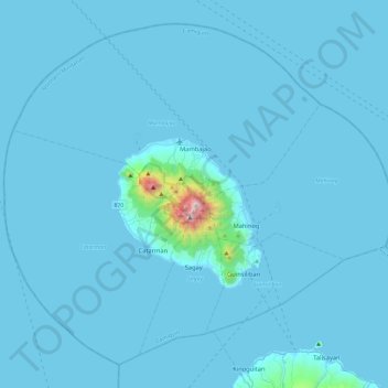
Name: Camiguin topographic map, elevation, terrain.

Location: Camiguin, Northern Mindanao, Philippines (8.98788 124.49669 9.39311 124.96259)

Average elevation: 115 ft

Minimum elevation: -3 ft

Maximum elevation: 5,253 ft

Other topographic maps

Click on a map to view its topography, its elevation and its terrain.

Baguio

Philippines

In 1903, Filipinos, Japanese and Chinese workers were hired to build Kennon Road, the first road directly connecting Baguio with the lowlands of La Union and Pangasinan. Before this, the only road to Benguet was Naguilian Road, and it was largely a horse trail at higher elevations. Camp John Hay was…

Average elevation: 2,890 ft

Cebu City

Philippines > Cebu > Cebu City

Average elevation: 459 ft

Valenzuela

Philippines

The highest elevation point is 38 meters (125 ft) above sea level. Having a surface gradient of 0.55% and a gentle slope, hilly landscape is located in the industrial section of the city in Canumay. The average elevation point is 2 meters (6.6 ft) above sea level.

Average elevation: 79 ft

Norzagaray

Philippines > Bulacan

Average elevation: 217 ft

Quezon City

Philippines

Founded as a pueblo by Saint Pedro Bautista in 1590, San Francisco del Monte may be considered Quezon City's oldest district. The original land area of the old town of San Francisco del Monte was approximately2.5 square kilometres (1.0 sq mi) and covered parts of what is currently known as Project 7 and 8 and…

Average elevation: 187 ft

Marikina

Philippines

Average elevation: 262 ft

Santa Rosa

Philippines > Laguna > Santa Rosa

Average elevation: 213 ft

Ilagan

Philippines > Isabela

Abuan River is the main river of the Northern Sierra Madre Natural Park. It has an average elevation of 82 meters above sea level, and feeds the Abuan watershed in the city. Tourists and visitors can explore the diverse animal and plant life in one of the country’s remaining lush virgin forests. On January…

Average elevation: 404 ft

Batiawan

Philippines > Zambales > Subic

Average elevation: 774 ft

Taguig

Philippines

Average elevation: 128 ft

Batanes

Philippines

Average elevation: 85 ft

Bohol

Philippines

Average elevation: 381 ft

Rizal

Philippines

Average elevation: 312 ft

Carcar

Philippines > Cebu

The land is generally level with less than 18% slope comprising 78.7% of the total land area. Areas with slopes ranging from 18 to 50% cover 19.3% of the total land area and those over 50% slope comprise approximately 1.9%. The highest recorded elevation is a little over 660 metres (2,170 ft) above sea level,…

Average elevation: 318 ft

Tagaytay

Philippines > Cavite

The southern and eastern portions of Tagaytay are covered by hills and mountains which is generally forests, pine trees and open grasslands. The city lies along Tagaytay Ridge, a ridge stretching about 32 kilometres (20 mi) from Mount Batulao in the west to Mount Sungay in the east with elevations averaging…

Average elevation: 751 ft

Bacolod

Philippines

Bacólod (English: Bacolod), is derived from bakólod (Old Spelling: bacólod), the Old Hiligaynon (Old Ilonggo) (Old Spelling: Ylongo and Ilongo) word for a "hill, turtle, mound, rise, hillock, down, any small eminence or elevation", since the resettlement was founded on a stony, hilly area, now the barangay…

Average elevation: 161 ft

Gamu

Philippines > Isabela

Average elevation: 161 ft

Labangan

Philippines > Zamboanga del Sur

Average elevation: 43 ft

Samar

Philippines > Samar

Average elevation: 505 ft

Tarlac

Philippines

Average elevation: 358 ft

Parañaque

Philippines

Average elevation: 46 ft

Nueva Vizcaya

Philippines

Average elevation: 351 ft

Albay

Philippines

Average elevation: 157 ft

Samar

Philippines

Average elevation: 125 ft

Zamboanga del Sur

Philippines

Average elevation: 387 ft

Daanbantayan

Philippines > Cebu

Average elevation: 26 ft

San Fernando

Philippines > La Union

Average elevation: 266 ft

Iligan

Philippines

Average elevation: 751 ft

Sual

Philippines > Pangasinan

Average elevation: 272 ft

Lapu-Lapu

Philippines

Average elevation: 305 ft

Pasay

Philippines

Average elevation: 46 ft

Mandaluyong

Philippines

Another claims that the Spaniards named the place based on the report of a navigator named Acapulco, who saw the rolling hills frequently being lashed at by daluyong (“big waves from the sea”). This seems to confirm traditional pre-Hispanic stories that giant waves from the sea would meet the adjoining…

Average elevation: 108 ft

Calamba

Philippines > Laguna

Average elevation: 328 ft

Bontoc

Philippines > Mountain Province

Average elevation: 3,750 ft

Patag Island

Philippines

Average elevation: 0 ft

Kota Island

Philippines

Average elevation: 0 ft

Lankiam Cay

Philippines

Average elevation: 0 ft

Mantalongon

Philippines > Cebu

Average elevation: 623 ft

Iriga

Philippines

Average elevation: 377 ft

Davao Gulf

Philippines

Average elevation: 0 ft

Argao

Philippines > Cebu

Average elevation: 102 ft

Lawak Island

Philippines

Average elevation: 0 ft

Muñoz

Philippines > Nueva Ecija

Muñoz is situated 30 kilometres (19 mi) from Cabanatuan, 44 kilometres (27 mi) from Palayan, and 146 kilometres (91 mi) north of the capital Manila. Due to its rich topography and tropical climate, it is now home to agricultural research and technology centers, committed to the production of information and…

Average elevation: 282 ft

Malico

Philippines > Nueva Vizcaya > San Nicolas

Average elevation: 4,285 ft

Taytay

Philippines > Palawan

Average elevation: 180 ft

Surigao del Sur

Philippines

Average elevation: 899 ft

Candaba

Philippines

Average elevation: 20 ft

Davao City

Philippines

Average elevation: 213 ft

Kinatihan II

Philippines

Average elevation: 72 ft

Ibabang Bukal

Philippines

Average elevation: 833 ft

Cabatang

Philippines

Average elevation: 1,099 ft

Pinget

Philippines

Average elevation: 4,692 ft

Caloocan

Philippines

Average elevation: 266 ft

Aurora Hill North Central

Philippines

Average elevation: 4,852 ft

Besigan

Philippines

Average elevation: 1,916 ft

Talomo River

Philippines

Average elevation: 659 ft

Asin

Philippines

Average elevation: 4,334 ft

Catambungan

Philippines

Average elevation: 16 ft

Tablas Strait

Philippines

Average elevation: 0 ft

Buenavista

Philippines

Average elevation: 367 ft

Poliwes

Philippines

Average elevation: 4,583 ft

Teodora Alonzo

Philippines

Average elevation: 4,787 ft

Manggahan

Philippines

Average elevation: 23 ft

Bakakeng Norte

Philippines

Average elevation: 4,524 ft

New Carmen

Philippines

Average elevation: 322 ft

Crossing Bayabas

Philippines

Average elevation: 72 ft

Marinduque

Philippines

Average elevation: 177 ft

Bakakeng Central

Philippines

Average elevation: 4,633 ft

Pasig

Philippines

Average elevation: 151 ft

Pacdal

Philippines

Average elevation: 4,751 ft

Macasandig

Philippines

Average elevation: 138 ft

Nueva Ecija

Philippines

Average elevation: 367 ft

Antique

Philippines

Average elevation: 151 ft

Cebu

Philippines

Average elevation: 292 ft

Zone IV

Philippines

Average elevation: 13 ft

Sorsogon

Philippines

Average elevation: 131 ft

Camarines Sur

Philippines

Average elevation: 184 ft

Mines View

Philippines

Average elevation: 4,695 ft

Masbate

Philippines

Average elevation: 177 ft

Bulacan

Philippines

Average elevation: 344 ft

City Camp Proper

Philippines

Average elevation: 4,692 ft

Palawan

Philippines

Average elevation: 30 ft

Leyte

Philippines

Average elevation: 177 ft

Quirino

Philippines

Average elevation: 354 ft

Cavite

Philippines

Average elevation: 253 ft

Isabela

Philippines

Average elevation: 328 ft

Mount Palanan

Philippines

Average elevation: 2,995 ft

Luna

Philippines > La Union

Average elevation: 26 ft

Magat River

Philippines

Average elevation: 151 ft

Las Piñas

Philippines

Average elevation: 46 ft

Silang

Philippines > Cavite > Silang

Average elevation: 1,001 ft

Pasig River

Philippines

Average elevation: 69 ft

Leyte Gulf

Philippines

Average elevation: 0 ft

Gumaca

Philippines > Quezon

Average elevation: 112 ft

Mandaue

Philippines

It is one of the two (the other one being the municipality of Consolacion) local government units located within the mainland Metro Cebu where the elevation of land is less than 100 m (330 ft).

Average elevation: 358 ft

Lucban

Philippines

Average elevation: 1,654 ft

Davao City

Philippines

Average elevation: 184 ft

Bacarra

Philippines > Ilocos Norte

Average elevation: 79 ft

Cavinti

Philippines > Laguna > Cavinti

Average elevation: 820 ft

San Juan

Philippines

"San Juan" is a contraction of the city's traditional name of "San Juan del Monte" (lit. 'Saint John of the Mountain'). As with numerous other places in the Philippines, the name combines a patron saint and a toponym; in this case Saint John the Baptist with the locale's hilly terrain and relatively higher…

Average elevation: 115 ft

Gear up for your next adventure:

🗃️Trail First Aid Kit - Essential kit for outdoor injuries and emergencies
🎁Geography Themed Gifts - Unique gift ideas for map lovers and geography enthusiasts
🧺Microfiber Travel Towels - Compact and fast-drying towels for trail use
🗺️Topographic Maps - Detailed topo maps for hiking, exploring and outdoor navigation
🪶Camp Gear Gift Set - Perfect gift bundle for outdoor fans

As an Amazon Associate, this site earns from qualifying purchases at no extra cost to you.