Sheffield topographic map
Click on the map to display elevation.
Sheffield
Sheffield nestles on the eastern foothills of the Pennines and is sculpted by a dramatic hill-and-valley system formed where five rivers — the Don, Sheaf, Rivelin, Loxley and Porter — converge, producing steep-sided valleys and gritstone ridgelines with much of the urban area built directly onto hillsides that give sweeping views across the city and out to the moors. The city’s elevation is strikingly varied: its low point is around 29 m above sea level at Blackburn Meadows while the highest ground reaches about 548 m at High Stones, a westward rise that carries the urban fringe into the high, windswept peat moorlands of the Peak District — roughly one-third of Sheffield’s area falls inside the national park. Most housing sits on mid-slopes (around 100–200 m) with the city centre nearer 70–80 m, producing a distinctive cityscape of river-cut gullies, steep residential terraces and open moorland shoulders that shaped Sheffield’s industrial past and now frames its views.
About this map
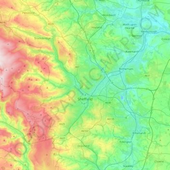
Name: Sheffield topographic map, elevation, terrain.
Location: Sheffield, South Yorkshire, England, United Kingdom (53.30451 -1.80147 53.50310 -1.32467)
Average elevation: 551 ft
Minimum elevation: -16 ft
Maximum elevation: 1,732 ft
Other topographic maps
Click on a map to view its topography, its elevation and its terrain.
Leeds
Lying in the eastern foothills of the Pennines, there is a significant variation in elevation within the city's built-up area. The district ranges from 1,115 feet (340 m) in the far west on the slopes of Ilkley Moor to about 33 feet (10 m) where the rivers Aire and Wharfe cross the eastern boundary. Land rises…
Average elevation: 308 ft
Halifax
United Kingdom > England > Calderdale
Topographically, Halifax is located in the south-eastern corner of the moorland region called the South Pennines. Halifax is situated about 4 miles (6 km) from the M62 motorway, close to Bradford and Huddersfield. The A641 road links the town with Brighouse, Bradford and Huddersfield. The Hebble Brook joins…
Average elevation: 640 ft



Accrington
United Kingdom > England > Lancashire > Hyndburn
Geographical coordinates: 53° 46' 0" North, 2° 21' 0" West. Height above sea level: there is a spot height outside the Market Hall which is 133.5 metres (438 ft) the benchmark on the side of the neighbouring Town Hall is 441.10 feet (134.45 m). The highest height in the town is 320 metres (1,050 ft) which is…
Average elevation: 653 ft
Stoke-on-Trent
United Kingdom > England > Stoke-on-Trent > Stoke-on-Trent
In 1919, the borough proposed to expand further and annex the neighbouring borough of Newcastle-under-Lyme and the Wolstanton United Urban District, both to the west of Stoke. This never took place, due to strong objections from Newcastle Corporation. A further attempt was made in 1930, with the promotion of…
Average elevation: 525 ft




Darwen
United Kingdom > England > Darwen
Much of the town was built between about 1850 and 1900; placenames, date stones in terraces, and the vernacular architecture of cellars, local stone, locally-made brick, pipework and tiles and leaded glass, the last now mostly gone, reflect this. It was one of the first places in the world to have steam trams.…
Average elevation: 791 ft
Bradford
Bradford is located at 53°45′00″N 01°50′00″W / 53.75000°N 1.83333°W / 53.75000; -1.83333 (53.7500, -1.8333)1. Topographically, it is located in the eastern moorland region of the South Pennines.
Average elevation: 548 ft
Hucknall
United Kingdom > England > Nottinghamshire > Ashfield
Hucknall Airfield, built in 1916, became RAF Hucknall. From 1927, Rolls-Royce began using the airfield for flight tests. During World War II, the aerodrome at Hucknall launched the first flight of a P-51 Mustang fitted with a Rolls-Royce Merlin Engine. The Merlin, replacing the earlier Allison V-1710 engine,…
Average elevation: 341 ft
Burton upon Trent
United Kingdom > England > Staffordshire > East Staffordshire
Burton is about 109 miles (175 km) north west of London, about 30 miles north east of Birmingham, the UK's second largest city and about 23 miles east of the county town Stafford. It is at the easternmost border of the county of Staffordshire with Derbyshire, its suburbs and the course of the River Trent…
Average elevation: 226 ft


King's Lynn
United Kingdom > England > Norfolk > King's Lynn and West Norfolk
Average elevation: 23 ft
Portsmouth
United Kingdom > England > Hampshire > Portsmouth
By road, Portsmouth lies 73.5 miles (118.3 km) from Central London, 49.5 miles (79.7 km) west of Brighton, and 22.3 miles (35.9 km) east of Southampton. Portsmouth is situated primarily on Portsea Island and is the United Kingdom's only island city, although parts of it have expanded onto the mainland. Gosport…
Average elevation: 92 ft



Gateshead
United Kingdom > England > Tyne and Wear > Gateshead
One of the most distinguishing features of Gateshead is its topography. The land rises 230 feet (70 m) from Gateshead Quays to the town centre and continues rising to a height of 525 feet (160 m) at Queen Elizabeth Hospital in Sheriff Hill. This is in contrast to the flat and low lying Team Valley located on…
Average elevation: 203 ft
Littleborough
United Kingdom > England > Rochdale
In the late 18th century, the low-altitude Summit Gap between Littleborough and Walsden was approved as the best route over the Pennines for the Rochdale Canal and the Manchester to Leeds railway; Hollingworth Lake was built at Littleborough's south side as a feeder reservoir to regulate the waters of the…
Average elevation: 873 ft
Slaithwaite
United Kingdom > England > Kirklees
In the 1848 edition of 'A Topographical Dictionary of England', Samuel Lewis (the editor) wrote:- "the lands are in meadow and pasture, with a small portion of arable; the scenery is bold and romantic. In the quarries of the district are found vegetable fossils, especially firs and other mountain trees. The…
Average elevation: 791 ft


Ashton-under-Lyne
United Kingdom > England > Tameside
At 53°29′38″N 2°6′11″W / 53.49389°N 2.10306°W / 53.49389; -2.10306 (53.4941°, −2.1032°), and 160 miles (257 km) north-northwest of London, Ashton-under-Lyne stands on the north bank of the River Tame, about 35 feet (11 m) above the river. Described in Samuel Lewis's A Topographical…
Average elevation: 423 ft



Kinder Scout
United Kingdom > England > Derbyshire > High Peak
To the north across the Snake Pass lie the high moors of Bleaklow and Black Hill, which are of similar elevation.
Average elevation: 1,821 ft


Chapel-en-le-Frith
United Kingdom > England > High Peak > Chapel-en-le-Frith
Average elevation: 1,063 ft


Salisbury
United Kingdom > England > Salisbury
Bishop of Salisbury Hubert Walter was instrumental in the negotiations with Saladin during the Third Crusade, but he spent little time in his diocese prior to his elevation to archbishop of Canterbury. The brothers Herbert and Richard Poore succeeded him and began planning the relocation of the cathedral into…
Average elevation: 315 ft

Castle Park
United Kingdom > England > Bristol > Bristol
The main objection to this plan came from the independent traders who did not wish to relocate because they felt that the proposed new shopping area was 'off the beaten track'. This objection was not unreasonable, as in its pre-war topography Bristol had a long shopping axis that started at Stapleton Road to…
Average elevation: 85 ft
Malvern
United Kingdom > England > Worcestershire > Malvern Hills
Malvern lies in the Lower Severn/Avon plain affording it a degree of shelter caused by virtue of its nestling in between the Cotswold hills to the east, the Welsh Hills and Mountains to the west, and Birmingham plateau to the north. Although as with all the British Isles it has a maritime climate, the local…
Average elevation: 312 ft