Geolocate

Wadley topographic map

Click on the map to display elevation.

About this map
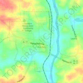
Name: Wadley topographic map, elevation, terrain.

Location: Wadley, Randolph County, Alabama, United States (33.11254 -85.58702 33.13447 -85.55076)

Average elevation: 692 ft

Minimum elevation: 600 ft

Maximum elevation: 814 ft

Randolph County trails, hiking, mountain biking, running and outdoor activities

Other topographic maps

Click on a map to view its topography, its elevation and its terrain.
Newell

United States > Alabama > Randolph County

Average elevation: 938 ft

Wedowee

United States > Alabama > Randolph County

Average elevation: 912 ft

Flat Rock

United States > Alabama > Randolph County

Average elevation: 830 ft

Gear up for your next adventure:

🥾Women's Hiking Boots - Top-rated trail boots with ankle support and superior grip
🧦Hiking Socks - Comfortable socks to prevent blisters on long hikes
🛏️Cold Weather Sleeping Bag - Warm sleeping bag for cold conditions
🪶Fire Starter Kit - Reliable fire starter for survival and camping
🩹Survival Bandages - High‑quality bandages for emergencies

As an Amazon Associate, this site earns from qualifying purchases at no extra cost to you.