Geolocate

Mound City topographic map

Click on the map to display elevation.

About this map
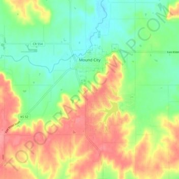
Name: Mound City topographic map, elevation, terrain.

Location: Mound City, Linn County, Kansas, 66056, United States (38.10968 -94.89664 38.14963 -94.79678)

Average elevation: 945 ft

Minimum elevation: 820 ft

Maximum elevation: 1,102 ft

Linn County trails, hiking, mountain biking, running and outdoor activities

Other topographic maps

Click on a map to view its topography, its elevation and its terrain.
Farlinville

United States > Kansas > Linn County

Average elevation: 876 ft

Centerville

United States > Kansas > Linn County

Average elevation: 942 ft

Gear up for your next adventure:

😴Insulated Sleeping Pads - Compact and warm pads for high-elevation camping
🩳Quick‑Dry Hiking Shorts - Comfortable and quick‑dry shorts for summer hiking
🏫Relief Map Kits - Hands-on tools for teaching landforms and elevation
⛺Backpacking Tent - Lightweight and durable tent for multi‑day hikes
👓Polarized Sunglasses - Outdoor sunglasses for glare reduction

As an Amazon Associate, this site earns from qualifying purchases at no extra cost to you.