Geolocate

Centerville topographic map

Click on the map to display elevation.

About this map

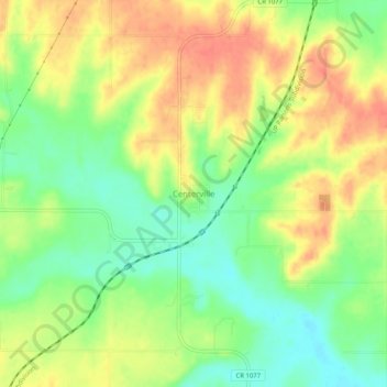
Name: Centerville topographic map, elevation, terrain.

Location: Centerville, Linn County, Kansas, 66014, United States (38.20086 -95.03414 38.24086 -94.99414)

Average elevation: 942 ft

Minimum elevation: 853 ft

Maximum elevation: 1,024 ft

Linn County trails, hiking, mountain biking, running and outdoor activities

Other topographic maps

Click on a map to view its topography, its elevation and its terrain.

Mound City

United States > Kansas > Linn County

Average elevation: 945 ft

Pleasanton

United States > Kansas > Linn County

Average elevation: 856 ft

Linn Valley

United States > Kansas > Linn County

Average elevation: 919 ft

La Cygne

United States > Kansas > Linn County

Average elevation: 840 ft

Prescott

United States > Kansas > Linn County

Average elevation: 869 ft

Mound City

United States > Kansas > Linn County

Average elevation: 945 ft

La Cygne

United States > Kansas > Linn County

Average elevation: 840 ft

Blue Mound

United States > Kansas > Linn County

Blue Mound was laid out in 1882. It was named by its first postmaster, John Q. Adams, because its elevation is said to look blue from a distance.

Average elevation: 1,056 ft

Pleasanton

United States > Kansas > Linn County

Average elevation: 856 ft

Mound City

United States > Kansas > Linn County

Average elevation: 945 ft

Prescott

United States > Kansas > Linn County

Average elevation: 869 ft

Gear up for your next adventure:

🎒Trekking Poles - Sturdy poles for balance and stability on rough terrain
📻Weather Alert Radios - Stay informed of storm risks while off-the-grid
🧼Biodegradable Camping Soap - Eco‑friendly soap for outdoor hygiene
🛌Ultralight Sleeping Bags - Compact down bags for cold nights in the wilderness
🧯Portable Fire Pit - Compact fire pit for camping spots

As an Amazon Associate, this site earns from qualifying purchases at no extra cost to you.