Geolocate

Luna topographic map

Click on the map to display elevation.

About this map

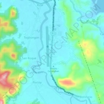
Name: Luna topographic map, elevation, terrain.

Location: Luna, Surigao del Norte, Caraga, 8400, Philippines (9.73545 125.46282 9.77545 125.50282)

Average elevation: 121 ft

Minimum elevation: -3 ft

Maximum elevation: 627 ft

Other topographic maps

Click on a map to view its topography, its elevation and its terrain.

Alegria

Philippines > Surigao Del Norte

Average elevation: 709 ft

Siargao

Philippines > Surigao Del Norte

Average elevation: 36 ft

Mayag River

Philippines > Surigao Del Norte > Cantugas

Average elevation: 597 ft

Burgos

Philippines > Surigao Del Norte

Average elevation: 98 ft

San Isidro

Philippines > Surigao Del Norte > San Isidro

Average elevation: 89 ft

Gear up for your next adventure:

🏥Hiking First Aid Kits - Comprehensive medical kits for remote trail injuries
🪶LED Camping Lantern - Bright lantern for camp lighting
📖Nature Tracking Books - Learn to track wildlife and terrain
🍳Camping Cook Set - Complete cookware for outdoor meals
☀️Outdoor Sunscreen - High protection sunscreen for outdoor activities

As an Amazon Associate, this site earns from qualifying purchases at no extra cost to you.