
Make a donation
Gear up for your next adventure:
As an Amazon Associate, this site earns from qualifying purchases at no extra cost to you.
Deerfield topographic map
Click on the map to display elevation.
Make a donation
Gear up for your next adventure:
As an Amazon Associate, this site earns from qualifying purchases at no extra cost to you.
About this map
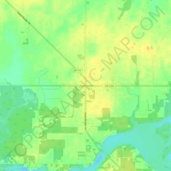
Name: Deerfield topographic map, elevation, terrain.
Average elevation: 1,053 ft
Minimum elevation: 1,001 ft
Maximum elevation: 1,096 ft
Portage County trails, hiking, mountain biking, running and outdoor activities
Make a donation
Gear up for your next adventure:
As an Amazon Associate, this site earns from qualifying purchases at no extra cost to you.
Other topographic maps
Click on a map to view its topography, its elevation and its terrain.
Tom S Cooperrider-Kent Bog State Nature Preserve
United States > Ohio > Portage County
Average elevation: 1,099 ft
Make a donation
Gear up for your next adventure:
As an Amazon Associate, this site earns from qualifying purchases at no extra cost to you.
Franklin Township
United States > Ohio > Portage County
Located on the western end of the Glaciated Allegheny Plateau, the topography of Franklin Township includes rolling hills and varied terrain. Lake Rockwell, the main drinking water source for the city of Akron, is in the northeastern part of the township. It was created in 1913 and impounds water from the…
Average elevation: 1,076 ft
Nelson Ledges Quarry Park
United States > Ohio > Portage County > Garrettsville
Average elevation: 1,004 ft
Make a donation
Gear up for your next adventure:
As an Amazon Associate, this site earns from qualifying purchases at no extra cost to you.
Make a donation
Gear up for your next adventure:
As an Amazon Associate, this site earns from qualifying purchases at no extra cost to you.