
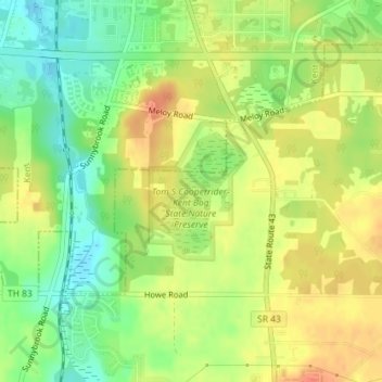
Tom S Cooperrider-Kent Bog State Nature Preserve topographic map
Interactive map
Click on the map to display elevation.
About this map
Name: Tom S Cooperrider-Kent Bog State Nature Preserve topographic map, elevation, terrain.
Average elevation: 1,099 ft
Minimum elevation: 1,020 ft
Maximum elevation: 1,165 ft
Portage County trails, hiking, mountain biking, running and outdoor activities
Other topographic maps
Click on a map to view its topography, its elevation and its terrain.
Franklin Township
United States > Ohio > Portage County
Located on the western end of the Glaciated Allegheny Plateau, the topography of Franklin Township includes rolling hills and varied terrain. Lake Rockwell, the main drinking water source for the city of Akron, is in the northeastern part of the township. It was created in 1913 and impounds water from the…
Average elevation: 1,076 ft