
Make a donation
Gear up for your next adventure:
As an Amazon Associate, this site earns from qualifying purchases at no extra cost to you.
Brimfield topographic map
Click on the map to display elevation.
Make a donation
Gear up for your next adventure:
As an Amazon Associate, this site earns from qualifying purchases at no extra cost to you.
About this map
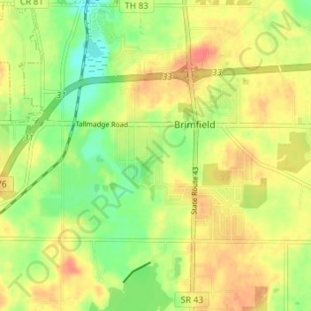
Name: Brimfield topographic map, elevation, terrain.
Average elevation: 1,115 ft
Minimum elevation: 1,030 ft
Maximum elevation: 1,184 ft
Portage County trails, hiking, mountain biking, running and outdoor activities
Make a donation
Gear up for your next adventure:
As an Amazon Associate, this site earns from qualifying purchases at no extra cost to you.
Other topographic maps
Click on a map to view its topography, its elevation and its terrain.
Tom S Cooperrider-Kent Bog State Nature Preserve
United States > Ohio > Portage County
Average elevation: 1,099 ft
Make a donation
Gear up for your next adventure:
As an Amazon Associate, this site earns from qualifying purchases at no extra cost to you.
Nelson Ledges Quarry Park
United States > Ohio > Portage County > Garrettsville
Average elevation: 1,004 ft
Make a donation
Gear up for your next adventure:
As an Amazon Associate, this site earns from qualifying purchases at no extra cost to you.