Geolocate

Lee Stocking Island topographic map

Click on the map to display elevation.

About this map

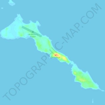
Name: Lee Stocking Island topographic map, elevation, terrain.

Location: Lee Stocking Island, Exuma, Bahamas (23.75038 -76.11888 23.78324 -76.07035)

Average elevation: 3 ft

Minimum elevation: -3 ft

Maximum elevation: 118 ft

Other topographic maps

Click on a map to view its topography, its elevation and its terrain.

Farmers Hill

Bahamas > Exuma

Average elevation: 13 ft

Darby Island

Bahamas > Exuma

Average elevation: 7 ft

Cave Cay

Bahamas > Exuma

Average elevation: 3 ft

Hartswell

Bahamas > Exuma

Average elevation: 3 ft

Little Exuma Island

Bahamas > Exuma

Average elevation: 3 ft

Pipe Cay

Bahamas > Exuma

Average elevation: 3 ft

Gear up for your next adventure:

🪶Camp Gear Gift Set - Perfect gift bundle for outdoor fans
🪶Compact Camp Shovel - Folding shovel for campsite tasks
📚Navigation Handbooks - Master the art of reading topographic maps and using a compass
🧤Tactile Hiking Gloves - Keep hands warm while operating GPS and smartphone screens
🧴Hand Sanitizer - Keep hands clean while hiking

As an Amazon Associate, this site earns from qualifying purchases at no extra cost to you.