
Make a donation
Gear up for your next adventure:
As an Amazon Associate, this site earns from qualifying purchases at no extra cost to you.
Richlandtown topographic map
Click on the map to display elevation.
Make a donation
Gear up for your next adventure:
As an Amazon Associate, this site earns from qualifying purchases at no extra cost to you.
About this map
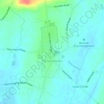
Name: Richlandtown topographic map, elevation, terrain.
Average elevation: 525 ft
Minimum elevation: 489 ft
Maximum elevation: 679 ft
Bucks County trails, hiking, mountain biking, running and outdoor activities
Make a donation
Gear up for your next adventure:
As an Amazon Associate, this site earns from qualifying purchases at no extra cost to you.
Other topographic maps
Click on a map to view its topography, its elevation and its terrain.
Village Shires
United States > Pennsylvania > Bucks County > Northampton Township
Average elevation: 187 ft
Make a donation
Gear up for your next adventure:
As an Amazon Associate, this site earns from qualifying purchases at no extra cost to you.
Feasterville
United States > Pennsylvania > Bucks County > Lower Southampton Township
Average elevation: 217 ft
Cornwells Heights
United States > Pennsylvania > Bucks County > Bensalem Township
Average elevation: 52 ft
Castle Valley
United States > Pennsylvania > Bucks County > Doylestown Township
Average elevation: 276 ft
Make a donation
Gear up for your next adventure:
As an Amazon Associate, this site earns from qualifying purchases at no extra cost to you.
Jericho Mountain
United States > Pennsylvania > Bucks County > Upper Makefield Township
Average elevation: 203 ft
Warrington
United States > Pennsylvania > Bucks County > Warrington Township > Warrington
Average elevation: 285 ft
Warminster
United States > Pennsylvania > Bucks County > Warminster Township > Warminster
Average elevation: 279 ft
Make a donation
Gear up for your next adventure:
As an Amazon Associate, this site earns from qualifying purchases at no extra cost to you.
Point Pleasant
United States > Pennsylvania > Bucks County > Plumstead Township
Average elevation: 348 ft
Southampton
United States > Pennsylvania > Bucks County > Upper Southampton Township
Average elevation: 246 ft
Lake Nockamixon
United States > Pennsylvania > Bucks County > Haycock Township
Average elevation: 495 ft
Make a donation
Gear up for your next adventure:
As an Amazon Associate, this site earns from qualifying purchases at no extra cost to you.
Smiths Corner
United States > Pennsylvania > Bucks County > Plumstead Township
Average elevation: 427 ft
Make a donation
Gear up for your next adventure:
As an Amazon Associate, this site earns from qualifying purchases at no extra cost to you.
Mechanicsville
United States > Pennsylvania > Bucks County > Buckingham Township
Average elevation: 384 ft
Make a donation
Gear up for your next adventure:
As an Amazon Associate, this site earns from qualifying purchases at no extra cost to you.
Newtown Grant
United States > Pennsylvania > Bucks County > Newtown Township
Average elevation: 285 ft
Warminster Heights
United States > Pennsylvania > Bucks County > Warminster Township
Average elevation: 282 ft
Woodbourne
United States > Pennsylvania > Bucks County > Middletown Township
Average elevation: 157 ft
Make a donation
Gear up for your next adventure:
As an Amazon Associate, this site earns from qualifying purchases at no extra cost to you.
Woodside
United States > Pennsylvania > Bucks County > Lower Makefield Township > Lower Makefield Township
Average elevation: 154 ft
Make a donation
Gear up for your next adventure:
As an Amazon Associate, this site earns from qualifying purchases at no extra cost to you.
Applebachsville
United States > Pennsylvania > Bucks County > Haycock Township
Average elevation: 545 ft
Make a donation
Gear up for your next adventure:
As an Amazon Associate, this site earns from qualifying purchases at no extra cost to you.
Blooming Glen
United States > Pennsylvania > Bucks County > Hilltown Township
Average elevation: 430 ft
Bucksville
United States > Pennsylvania > Bucks County > Nockamixon Township
Average elevation: 499 ft
Carversville
United States > Pennsylvania > Bucks County > Solebury Township
Average elevation: 377 ft
Make a donation
Gear up for your next adventure:
As an Amazon Associate, this site earns from qualifying purchases at no extra cost to you.
Make a donation
Gear up for your next adventure:
As an Amazon Associate, this site earns from qualifying purchases at no extra cost to you.
Forest Grove
United States > Pennsylvania > Bucks County > Buckingham Township
Average elevation: 272 ft
Gallows Hill
United States > Pennsylvania > Bucks County > Springfield Township
Average elevation: 548 ft
Make a donation
Gear up for your next adventure:
As an Amazon Associate, this site earns from qualifying purchases at no extra cost to you.
Make a donation
Gear up for your next adventure:
As an Amazon Associate, this site earns from qualifying purchases at no extra cost to you.
Holicong
United States > Pennsylvania > Bucks County > Buckingham Township > Buckingham
Average elevation: 315 ft
Kulps Corner
United States > Pennsylvania > Bucks County > Hilltown Township
Average elevation: 456 ft
Make a donation
Gear up for your next adventure:
As an Amazon Associate, this site earns from qualifying purchases at no extra cost to you.
Line Lexington
United States > Pennsylvania > Bucks County > New Britain Township
Average elevation: 354 ft
Make a donation
Gear up for your next adventure:
As an Amazon Associate, this site earns from qualifying purchases at no extra cost to you.
Mount Pleasant
United States > Pennsylvania > Bucks County > Hilltown Township
Average elevation: 571 ft
Penns Park
United States > Pennsylvania > Bucks County > Wrightstown Township > Wrightstown
Average elevation: 256 ft
Make a donation
Gear up for your next adventure:
As an Amazon Associate, this site earns from qualifying purchases at no extra cost to you.
Pleasant Valley
United States > Pennsylvania > Bucks County > Springfield Township
Average elevation: 509 ft
Make a donation
Gear up for your next adventure:
As an Amazon Associate, this site earns from qualifying purchases at no extra cost to you.
Upper Black Eddy
United States > Pennsylvania > Bucks County > Bridgeton Township
Average elevation: 328 ft
Make a donation
Gear up for your next adventure:
As an Amazon Associate, this site earns from qualifying purchases at no extra cost to you.
Washington Crossing
United States > Pennsylvania > Bucks County > Upper Makefield Township
Average elevation: 118 ft
Grenoble
United States > Pennsylvania > Bucks County > Northampton Township > Grenoble
Average elevation: 246 ft
Make a donation
Gear up for your next adventure:
As an Amazon Associate, this site earns from qualifying purchases at no extra cost to you.
Plumsteadville
United States > Pennsylvania > Bucks County > Plumstead Township
Average elevation: 525 ft
Lake Caroline Dam
United States > Pennsylvania > Bucks County > Falls Township > Fairless Hills
Average elevation: 105 ft
Taylorsville
United States > Pennsylvania > Bucks County > Upper Makefield Township > Washington Crossing > Taylorsville
Average elevation: 121 ft
Make a donation
Gear up for your next adventure:
As an Amazon Associate, this site earns from qualifying purchases at no extra cost to you.
Doylestown
United States > Pennsylvania > Bucks County > Doylestown
An electric telegraph station was built in 1846, and the North Pennsylvania Railroad completed a branch to Doylestown in 1856. The first gas lights were introduced in 1854. Because of the town's relatively high elevation and a lack of strong water power, substantial industrial development never occurred and…
Average elevation: 328 ft
Fountainville
United States > Pennsylvania > Bucks County > New Britain Township
Average elevation: 394 ft
Make a donation
Gear up for your next adventure:
As an Amazon Associate, this site earns from qualifying purchases at no extra cost to you.