
南坪街道 topographic map
Interactive map
Click on the map to display elevation.
About this map
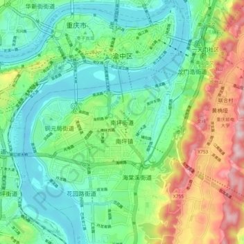
Name: 南坪街道 topographic map, elevation, terrain.
Location: 南坪街道, 南岸区, 重庆市主城都市区, 重庆市, 400060, 中国 (29.49369 106.52515 29.57369 106.60515)
Average elevation: 928 ft
Minimum elevation: 482 ft
Maximum elevation: 1,939 ft
Other topographic maps
Click on a map to view its topography, its elevation and its terrain.