Geolocate

Turners topographic map

Click on the map to display elevation.

About this map

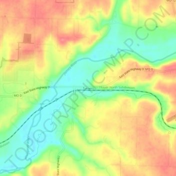
Name: Turners topographic map, elevation, terrain.

Location: Turners, Greene County, Missouri, United States (37.16088 -93.17546 37.20088 -93.13546)

Average elevation: 1,286 ft

Minimum elevation: 1,165 ft

Maximum elevation: 1,391 ft

Greene County trails, hiking, mountain biking, running and outdoor activities

Other topographic maps

Click on a map to view its topography, its elevation and its terrain.

Walnut Grove

United States > Missouri > Greene County

Average elevation: 1,171 ft

Ash Grove

United States > Missouri > Greene County

Average elevation: 1,056 ft

Fellows Lake

United States > Missouri > Greene County

Average elevation: 1,339 ft

James River

United States > Missouri > Greene County

Average elevation: 1,266 ft

Battlefield

United States > Missouri > Greene County

Average elevation: 1,243 ft

Fair Grove

United States > Missouri > Greene County

Average elevation: 1,240 ft

Strafford

United States > Missouri > Greene County

According to the United States Census Bureau, the city has a total area of 2.63 square miles (6.81 km2), all land. USGS Department of the Interior Original Survey 1838 and USGS Topographical Maps show the town along the White River Road that became the Telegraph Road to Saint Louis.

Average elevation: 1,434 ft

Wilsons Creek

United States > Missouri > Greene County > Springfield

Average elevation: 1,247 ft

Gear up for your next adventure:

🎒Gear Packing Cubes - Organize your backpack efficiently
Backpacking Tent - Lightweight and durable tent for multi‑day hikes
🪶Paracord Bracelet - Survival bracelet with built‑in tools
🩳Quick‑Dry Hiking Shorts - Comfortable and quick‑dry shorts for summer hiking
🔭Stargazing Telescopes - Perfect for camping in low-light pollution areas shown on maps

As an Amazon Associate, this site earns from qualifying purchases at no extra cost to you.