Geolocate

Walnut Grove topographic map

Click on the map to display elevation.

About this map

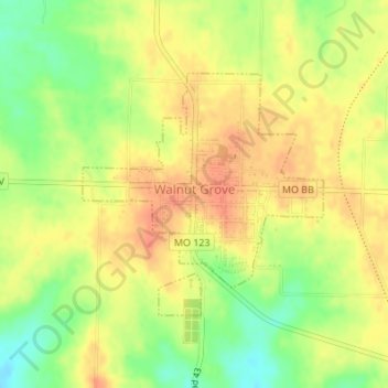
Name: Walnut Grove topographic map, elevation, terrain.

Location: Walnut Grove, Greene County, Missouri, United States (37.40235 -93.55949 37.41922 -93.53836)

Average elevation: 1,171 ft

Minimum elevation: 1,083 ft

Maximum elevation: 1,230 ft

Greene County trails, hiking, mountain biking, running and outdoor activities

Other topographic maps

Click on a map to view its topography, its elevation and its terrain.

Ebenezer

United States > Missouri > Greene County

Average elevation: 1,247 ft

Sacville

United States > Missouri > Greene County

Average elevation: 1,093 ft

Fellows Lake

United States > Missouri > Greene County

Average elevation: 1,339 ft

James River

United States > Missouri > Greene County

Average elevation: 1,266 ft

Republic

United States > Missouri > Greene County > Republic > Republic

Average elevation: 1,270 ft

Turners

United States > Missouri > Greene County

Average elevation: 1,286 ft

Mascot

United States > Missouri > Greene County

Average elevation: 1,234 ft

Wilsons Creek

United States > Missouri > Greene County > Springfield

Average elevation: 1,247 ft

Gear up for your next adventure:

📷Action Cameras - Rugged cameras to document your journeys across rugged terrain
🧷Carabiner Set - Durable clips for gear attachment
🧦Merino Wool Socks - Moisture-wicking, blister-preventing socks for long treks
🧭GPS Watch Accessories - Bands and chargers for GPS watches
☀️Outdoor Sunscreen - High protection sunscreen for outdoor activities

As an Amazon Associate, this site earns from qualifying purchases at no extra cost to you.