Geolocate

Dema topographic map

Click on the map to display elevation.

About this map

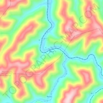
Name: Dema topographic map, elevation, terrain.

Location: Dema, Floyd County, Kentucky, 41666, United States (37.40038 -82.82516 37.44038 -82.78516)

Average elevation: 1,165 ft

Minimum elevation: 699 ft

Maximum elevation: 1,690 ft

Floyd County trails, hiking, mountain biking, running and outdoor activities

Other topographic maps

Click on a map to view its topography, its elevation and its terrain.

Wheelwright

United States > Kentucky > Floyd County

Average elevation: 1,460 ft

Allen

United States > Kentucky > Floyd County

Average elevation: 856 ft

Martin

United States > Kentucky > Floyd County

Average elevation: 883 ft

Gear up for your next adventure:

Backpacking Tents - Weight-optimized shelters for multi-day topographic surveys
🧭Outdoor Navigation Book - Learn advanced navigation skills
📡Handheld GPS Device - Reliable handheld GPS for outdoor navigation
🏫Relief Map Kits - Hands-on tools for teaching landforms and elevation
🧭Compass with Lanyard - Easy‑carry compass for navigation

As an Amazon Associate, this site earns from qualifying purchases at no extra cost to you.