
Make a donation
Gear up for your next adventure:
As an Amazon Associate, this site earns from qualifying purchases at no extra cost to you.
Cascais topographic map
Click on the map to display elevation.
Make a donation
Gear up for your next adventure:
As an Amazon Associate, this site earns from qualifying purchases at no extra cost to you.
Cascais
The settlement's prosperity led to its administrative independence from Sintra in 1364. On 7 June 1364, the people of Cascais obtained from King Peter I the elevation of the village to the status of town, necessitating the appointment of local judges and administrators. The townspeople were consequently obligated to pay the Crown 200 pounds of gold annually, as well as bearing the expense of paying the local administrators' salaries. Owing to the regions' wealth, these obligations were easily satisfied. The town and the surrounding lands were owned by a succession of feudal lords, the most famous of whom was João das Regras (died 1404), a lawyer and professor of the University of Lisbon who was involved in the ascension of King John I to power as the first King of the House of Aviz.
Make a donation
Gear up for your next adventure:
As an Amazon Associate, this site earns from qualifying purchases at no extra cost to you.
About this map
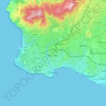
Name: Cascais topographic map, elevation, terrain.
Location: Cascais, Lisbon, Portugal (38.67589 -9.48655 38.76899 -9.30807)
Average elevation: 285 ft
Minimum elevation: 0 ft
Maximum elevation: 1,644 ft
Make a donation
Gear up for your next adventure:
As an Amazon Associate, this site earns from qualifying purchases at no extra cost to you.
Other topographic maps
Click on a map to view its topography, its elevation and its terrain.
Make a donation
Gear up for your next adventure:
As an Amazon Associate, this site earns from qualifying purchases at no extra cost to you.
Make a donation
Gear up for your next adventure:
As an Amazon Associate, this site earns from qualifying purchases at no extra cost to you.
Sintra
Portugal > Lisbon > Sintra (Santa Maria e São Miguel, São Martinho e São Pedro de Penaferrim)
The São João platform, along the northern flank of the Sintra Mountains, has altitudes between 100 metres (110 yd) and 150 metres (160 yd), while the southern part of the mountains, the Cascais platform, is lower: sloping from 150 metres (160 yd) to the sea, terminating along the coast, around 30 metres (33…
Average elevation: 620 ft
Make a donation
Gear up for your next adventure:
As an Amazon Associate, this site earns from qualifying purchases at no extra cost to you.
Beloura
Portugal > Lisbon > Sintra (Santa Maria e São Miguel, São Martinho e São Pedro de Penaferrim)
Average elevation: 597 ft
Make a donation
Gear up for your next adventure:
As an Amazon Associate, this site earns from qualifying purchases at no extra cost to you.
Make a donation
Gear up for your next adventure:
As an Amazon Associate, this site earns from qualifying purchases at no extra cost to you.
Make a donation
Gear up for your next adventure:
As an Amazon Associate, this site earns from qualifying purchases at no extra cost to you.
Miradouro de São Pedro de Alcântara
Portugal > Lisbon > Lisbon > Misericórdia
Average elevation: 157 ft
Make a donation
Gear up for your next adventure:
As an Amazon Associate, this site earns from qualifying purchases at no extra cost to you.
Make a donation
Gear up for your next adventure:
As an Amazon Associate, this site earns from qualifying purchases at no extra cost to you.
Almornos
Portugal > Lisbon > Almargem do Bispo, Pêro Pinheiro e Montelavar > Aruil de Baixo
Average elevation: 853 ft
Make a donation
Gear up for your next adventure:
As an Amazon Associate, this site earns from qualifying purchases at no extra cost to you.
Make a donation
Gear up for your next adventure:
As an Amazon Associate, this site earns from qualifying purchases at no extra cost to you.
Negrais
Portugal > Lisbon > Sintra > Almargem do Bispo, Pêro Pinheiro e Montelavar
Average elevation: 702 ft
Make a donation
Gear up for your next adventure:
As an Amazon Associate, this site earns from qualifying purchases at no extra cost to you.
Alfouvar de Cima
Portugal > Lisbon > Sintra > Almargem do Bispo, Pêro Pinheiro e Montelavar
Average elevation: 633 ft
Make a donation
Gear up for your next adventure:
As an Amazon Associate, this site earns from qualifying purchases at no extra cost to you.
Moita dos Ferreiros
Portugal > Lisbon > Moita dos Ferreiros > Moita dos Ferreiros
Average elevation: 328 ft
Make a donation
Gear up for your next adventure:
As an Amazon Associate, this site earns from qualifying purchases at no extra cost to you.
Rio Lizandro
Portugal > Lisbon > São João das Lampas e Terrugem > Terrugem > Armés
Average elevation: 420 ft
Sobral de Monte Agraço
Portugal > Lisbon > Sobral de Monte Agraço > Sobral de Monte Agraço
Average elevation: 696 ft
Make a donation
Gear up for your next adventure:
As an Amazon Associate, this site earns from qualifying purchases at no extra cost to you.