
Ballyaughlis topographic map
Click on the map to display elevation.
About this map
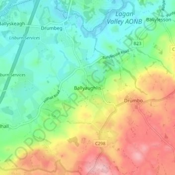
Name: Ballyaughlis topographic map, elevation, terrain.
Average elevation: 223 ft
Minimum elevation: 30 ft
Maximum elevation: 548 ft
Other topographic maps
Click on a map to view its topography, its elevation and its terrain.
Lagan Valley AONB
United Kingdom > Northern Ireland > County Down > Ballyskeagh
Average elevation: 217 ft
Scrabo Tower
United Kingdom > Northern Ireland > County Down > Newtownards
The tower's style is called Scottish Baronial by most recent authors.: "... mysteriously designed in the Scottish baronial style ..." The article in the Illustrated London News of 1857 says "... in the style of a Scottish chateau ...", whereas the article in the Dublin Builder of 1865 calls it "Scotch…
Average elevation: 128 ft
Tollymore Forest
United Kingdom > Northern Ireland > County Down > Bryansford
Average elevation: 535 ft
Ballycullen
United Kingdom > Northern Ireland > County Down > Newtownards > Ballycullen
Average elevation: 161 ft
Ballybarnes
United Kingdom > Northern Ireland > County Down > Bradshaw's Brae
Average elevation: 381 ft
Blaris (Castlereagh Upper portion)
United Kingdom > Northern Ireland > County Down > Hillhall
Average elevation: 213 ft
Tollymore Forest Park
United Kingdom > Northern Ireland > County Down > Castlewellan
Average elevation: 535 ft
Mourne Esplanade Amentity Area
United Kingdom > Northern Ireland > County Down > Kilkeel
Average elevation: 46 ft