
Newry topographic map
Click on the map to display elevation.
About this map
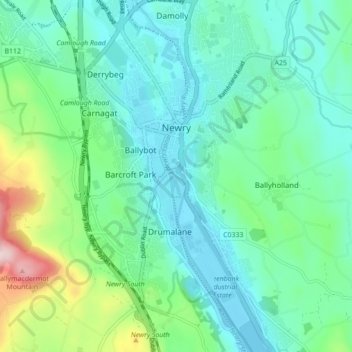
Name: Newry topographic map, elevation, terrain.
Location: Newry, County Down, Northern Ireland, United Kingdom (54.14495 -6.36011 54.19597 -6.30507)
Average elevation: 240 ft
Minimum elevation: -10 ft
Maximum elevation: 1,070 ft
Other topographic maps
Click on a map to view its topography, its elevation and its terrain.
Scrabo Tower
United Kingdom > Northern Ireland > County Down > Newtownards
The tower's style is called Scottish Baronial by most recent authors.: "... mysteriously designed in the Scottish baronial style ..." The article in the Illustrated London News of 1857 says "... in the style of a Scottish chateau ...", whereas the article in the Dublin Builder of 1865 calls it "Scotch…
Average elevation: 128 ft
Mourne Esplanade Amentity Area
United Kingdom > Northern Ireland > County Down > Kilkeel
Average elevation: 46 ft