Geolocate

Pingdingshan City topographic map

Click on the map to display elevation.

About this map

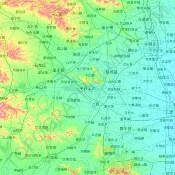
Name: Pingdingshan City topographic map, elevation, terrain.

Location: Pingdingshan City, Henan, 467000, China (33.13002 112.24168 34.34657 113.68389)

Average elevation: 581 ft

Minimum elevation: 184 ft

Maximum elevation: 3,599 ft

Other topographic maps

Click on a map to view its topography, its elevation and its terrain.

Yewa

China > Henan > Xi County > Xin County > Yanshancun

Average elevation: 666 ft

Fanli

China > Henan > Lushi County

Average elevation: 2,425 ft

Anyang

China > Henan

Anyang spans a total area of 7,355 square kilometres (2,840 sq mi). The city's elevation is generally higher in the west, with the foothills of the Taihang Mountains running through the area, and lower in the east, which comprises part of the North China Plain.

Average elevation: 335 ft

Kuangshan

China > Henan

Average elevation: 305 ft

Fuwa

China > Henan > Shangcheng County > Duntangcun

Average elevation: 466 ft

Xichuan

China > Henan > Xichuan County > Xichuan

Average elevation: 1,073 ft

Bao River

China > Henan > Shangqiu City

Average elevation: 115 ft

Gear up for your next adventure:

🧣Hiking Neck Gaiter - Multi‑use neck protection for outdoor weather
🎒Waterproof Dry Bags - Keep your electronics and maps dry inside your pack
🔥Camping Stove - Portable stove for camping and backcountry cooking
💧Water Filtration Bottles - Safely drink from streams and lakes while exploring
🗻Climbing Gear Basics - Essential gear for beginner climbers

As an Amazon Associate, this site earns from qualifying purchases at no extra cost to you.