
Make a donation
Gear up for your next adventure:
As an Amazon Associate, this site earns from qualifying purchases at no extra cost to you.
St. Dionys topographic map
Click on the map to display elevation.
Make a donation
Gear up for your next adventure:
As an Amazon Associate, this site earns from qualifying purchases at no extra cost to you.
About this map
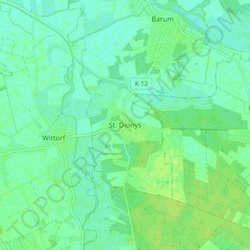
Name: St. Dionys topographic map, elevation, terrain.
Average elevation: 23 ft
Minimum elevation: 3 ft
Maximum elevation: 43 ft
Make a donation
Gear up for your next adventure:
As an Amazon Associate, this site earns from qualifying purchases at no extra cost to you.
Other topographic maps
Click on a map to view its topography, its elevation and its terrain.
Bleckede
Deutschland > Niedersachsen > Lüneburg
Bleckede liegt größtenteils im Urstromtal der Elbe, einige Ortsteile auch etwas höher auf dem Geestrücken bis zu 160 m über NN. Das gesamte Stadtgebiet ist Teil von zwei Nationalen Naturlandschaften, dem Biosphärenreservat Niedersächsische Elbtalaue und dem Naturpark Elbhöhen-Wendland.
Average elevation: 75 ft
Amt Neuhaus
Deutschland > Niedersachsen > Lüneburg
Das Gebiet der Gemeinde liegt im Elbe-Urstromtal nördlich des Naturparks Elbhöhen-Wendland und gehört selbst komplett zum Biosphärenreservat Niedersächsische Elbtalaue. Im nördlichen Bereich wird die Gemeinde von der Sude durchquert. In die Sude mündet bei Sückau die Rögnitz, nachdem sie von Südosten…
Average elevation: 89 ft
Barendorf
Deutschland > Niedersachsen > Lüneburg
Barendorf liegt am Westrand des Naturparks Elbhöhen-Drawehn. Die Gemeinde ist seit dem 1. März 1974 Verwaltungssitz der Samtgemeinde Ostheide mit den Gemeinden Barendorf, Neetze, Reinstorf, Thomasburg, Vastorf und Wendisch Evern.
Average elevation: 217 ft
Make a donation
Gear up for your next adventure:
As an Amazon Associate, this site earns from qualifying purchases at no extra cost to you.
Make a donation
Gear up for your next adventure:
As an Amazon Associate, this site earns from qualifying purchases at no extra cost to you.
Betzendorf
Deutschland > Niedersachsen > Lüneburg
In Glüsingen wurde 1927 das Lichtschulheim Lüneburger Land als höhere Schule für Knaben und Mädchen von dem Studienrat und Anhänger der Freikörperkultur Martin Fränzel gegründet. Seine Besonderheit war die Integration der Freikörperkultur in die pädagogische Konzeption. Neben der aufzubauenden…
Average elevation: 266 ft
Make a donation
Gear up for your next adventure:
As an Amazon Associate, this site earns from qualifying purchases at no extra cost to you.
Amelinghausen
Deutschland > Niedersachsen > Lüneburg
Der spätere Kaiser Otto I. ernannte im Jahre 961 Graf Hermann Billung zum Herzog der Sachsen. Seine Burg errichtete der neue Herzog auf dem Lüneburger Kalkberg. Von nun an war Lüneburg der Mittelpunkt seines Herrschaftsbereiches. Nach dem Tod des Verdener Bischofs Amelung, der ein Bruder Hermann Billungs…
Average elevation: 256 ft
Make a donation
Gear up for your next adventure:
As an Amazon Associate, this site earns from qualifying purchases at no extra cost to you.
Make a donation
Gear up for your next adventure:
As an Amazon Associate, this site earns from qualifying purchases at no extra cost to you.
Nahrendorf
Deutschland > Niedersachsen > Lüneburg
Nahrendorf liegt im Naturpark Elbhöhen-Wendland. Die Gemeinde gehört der Samtgemeinde Dahlenburg an, die ihren Verwaltungssitz in dem Flecken Dahlenburg hat.
Average elevation: 217 ft
Make a donation
Gear up for your next adventure:
As an Amazon Associate, this site earns from qualifying purchases at no extra cost to you.
Rullstorf
Deutschland > Niedersachsen > Lüneburg
Die Umgebung von Rullstorf ist seit Jahrtausenden besiedelt. Bei Ausgrabungen des Niedersächsischen Landesamtes für Denkmalpflege auf der Anhöhe des Kronsberges wurden die Reste eines Langhauses entdeckt, das sich anhand von Keramikfunden auf etwa 4000 Jahre vor Christus datieren ließ. Dabei handelt es…
Average elevation: 75 ft
Make a donation
Gear up for your next adventure:
As an Amazon Associate, this site earns from qualifying purchases at no extra cost to you.
Make a donation
Gear up for your next adventure:
As an Amazon Associate, this site earns from qualifying purchases at no extra cost to you.
Make a donation
Gear up for your next adventure:
As an Amazon Associate, this site earns from qualifying purchases at no extra cost to you.
Barum
Deutschland > Niedersachsen > Lüneburg
Die alten Bezeichnungen waren 1290 in Berne, 1304 in Barem, 1305 in Barme, 1319 in villa Barme, 1344 uilla Barem, 1348 to/van Barum, 1354 in Barem, 1366 van Barum, 1384 to Barem. Die Niederdeutsche Mundartwörterbücher verzeichnen unter barme, berme mehrere Deutungen, wie Grabenkante, Deichfluss, Böschung,…
Average elevation: 20 ft
Scharnebeck
Deutschland > Niedersachsen > Lüneburg
Das Schiffshebewerk Scharnebeck ist ein Teilstück des Elbe-Seitenkanals, der die Verbindung zwischen der Elbe (Höhe Artlenburg) und dem Mittellandkanal (bei Wolfsburg) bildet.
Average elevation: 72 ft
Make a donation
Gear up for your next adventure:
As an Amazon Associate, this site earns from qualifying purchases at no extra cost to you.