Geolocate

Mount McKinley topographic map

Click on the map to display elevation.

About this map

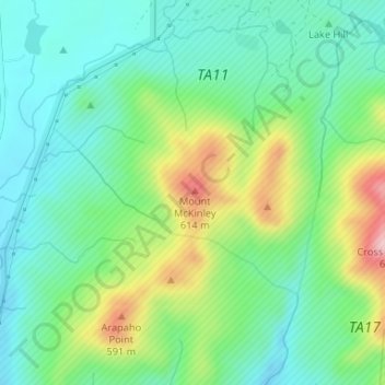
Name: Mount McKinley topographic map, elevation, terrain.

Location: Mount McKinley, Comanche County, Oklahoma, United States (34.69474 -98.61178 34.69484 -98.61168)

Average elevation: 1,634 ft

Minimum elevation: 1,407 ft

Maximum elevation: 2,139 ft

Comanche County trails, hiking, mountain biking, running and outdoor activities

Other topographic maps

Click on a map to view its topography, its elevation and its terrain.

Fort Sill

United States > Oklahoma > Comanche County

Average elevation: 1,368 ft

Comanche

United States > Oklahoma > Comanche County

Average elevation: 1,207 ft

Clear

United States > Oklahoma > Comanche County

Average elevation: 1,220 ft

Lake Lawtonka

United States > Oklahoma > Comanche County

Average elevation: 1,404 ft

Academic Hights

United States > Oklahoma > Comanche County > Lawton

Average elevation: 1,142 ft

Jackson Hole

United States > Oklahoma > Comanche County

Average elevation: 1,332 ft

Chattanooga

United States > Oklahoma > Comanche County

Average elevation: 1,138 ft

Indiahoma

United States > Oklahoma > Comanche County

Average elevation: 1,329 ft

Faxon

United States > Oklahoma > Comanche County

Average elevation: 1,096 ft

Geronimo

United States > Oklahoma > Comanche County

Average elevation: 1,076 ft

Sterling

United States > Oklahoma > Comanche County

Average elevation: 1,220 ft

Elgin

United States > Oklahoma > Comanche County

Average elevation: 1,289 ft

Gear up for your next adventure:

📦Dry Bags Set - Waterproof storage for electronics and clothes
🛏️Cold Weather Sleeping Bag - Warm sleeping bag for cold conditions
🗺️NatGeo Topo Maps - High-quality waterproof printed topographic maps of US Parks
📱Heavy-Duty Phone Cases - Drop-proof and waterproof protection for outdoor navigation
📶Satellite Messenger - Communication device off‑grid

As an Amazon Associate, this site earns from qualifying purchases at no extra cost to you.