Geolocate
👉 Easily get elevation data in JSON, GeoTIFF and KML formats using Elevation API
Thank you for supporting this site ❤️
Make a donation

Sterling topographic map

Click on the map to display elevation.

About this map

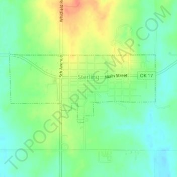
Name: Sterling topographic map, elevation, terrain.

Location: Sterling, Comanche County, Oklahoma, 73567, United States (34.74337 -98.18642 34.75374 -98.15930)

Average elevation: 1,220 ft

Minimum elevation: 1,158 ft

Maximum elevation: 1,306 ft

Comanche County trails, hiking, mountain biking, running and outdoor activities

Other topographic maps

Click on a map to view its topography, its elevation and its terrain.

Elk Mountain

United States > Oklahoma > Comanche County

Average elevation: 1,781 ft

Lake Lawtonka

United States > Oklahoma > Comanche County

Average elevation: 1,404 ft

Meers

United States > Oklahoma > Comanche County

Average elevation: 1,499 ft

Academic Hights

United States > Oklahoma > Comanche County > Lawton

Average elevation: 1,142 ft

Mount Scott

United States > Oklahoma > Comanche County

Average elevation: 1,627 ft

Comanche

United States > Oklahoma > Comanche County

Average elevation: 1,207 ft

Cross Mountain

United States > Oklahoma > Comanche County

Average elevation: 1,739 ft

Mount McKinley

United States > Oklahoma > Comanche County

Average elevation: 1,634 ft

Cove Acres

United States > Oklahoma > Comanche County > Cove Acres

Average elevation: 1,250 ft

Pratt Hill

United States > Oklahoma > Comanche County

Average elevation: 1,450 ft

Jackson Hole

United States > Oklahoma > Comanche County

Average elevation: 1,332 ft

Clear

United States > Oklahoma > Comanche County

Average elevation: 1,220 ft

Lawton

United States > Oklahoma > Comanche County > Lawton

Average elevation: 1,184 ft

Gear up for your next adventure:

👖Convertible Hiking Pants - Versatile zip-off pants for changing altitudes and temperatures
🔊Portable Camp Speaker - Music and alerts at camp
Solar GPS Watches - Advanced multisport watches with built-in topographic maps
🛰️Handheld GPS Units - Professional satellite navigators for precise backcountry mapping
🚗GPS Dash Cams - Record your scenic drives through mountain passes and canyons

As an Amazon Associate, this site earns from qualifying purchases at no extra cost to you.