
Maekel Region topographic map
Interactive map
Click on the map to display elevation.
About this map
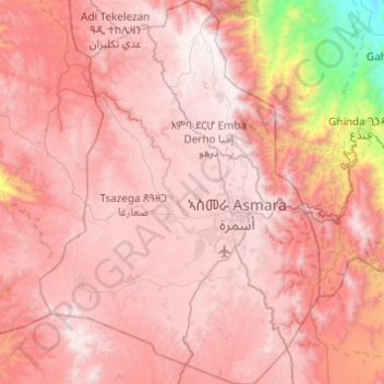
Name: Maekel Region topographic map, elevation, terrain.
Location: Maekel Region, Eritrea (15.12997 38.68128 15.60133 39.03764)
Average elevation: 6,040 ft
Minimum elevation: 787 ft
Maximum elevation: 8,550 ft
Central is the smallest region in Eritrea, and contains the major city and national capital, Asmara. Maekel is situated inland, and borders Anseba to the north-west, the Northern Red Sea region to the north-east, the Debub (Southern) region to the south, and Gash-Barka to the west. Much of the architecture in the region reflects Italian colonial influences. The topography of the region has highland plateau, which are cooler than the regions around the coastal plains. There are two rainy seasons, the heavier one during summer and the lighter one during spring. The climate and geography of the region along with other regions of Eritrea is similar to the one of Ethiopia. The average elevation in the region is around 1,800 m (5,900 ft) to 2,100 m (6,900 ft). The hottest month is May recording temperatures up to 30 °C (86 °F), while the coldest month is December to February when it reaches freezing temperature. The region received around 508 mm (20.0 in) of rainfall and the soil is conducive for agriculture.
Other topographic maps
Click on a map to view its topography, its elevation and its terrain.
Assab
Eritrea > Southern Red Sea Region
Assab, Southern Red Sea Region, Eritrea
Average elevation: 30 ft
Nabro
Eritrea > Southern Red Sea Region
Nabro, Southern Red Sea Region, Eritrea
Average elevation: 5,151 ft
Northern Red Sea Zone
Eritrea > Northern Red Sea Zone
Northern Red Sea Zone, Eritrea
Average elevation: 1,788 ft
Massawa
Eritrea > Northen Red Sea Region
Massawa, Northen Red Sea Region, Eritrea
Average elevation: 16 ft
Southern Red Sea Zone
Eritrea > Southern Red Sea Zone
Southern Red Sea Zone, Eritrea
Average elevation: 1,936 ft