
Simbal topographic map
Click on the map to display elevation.
About this map
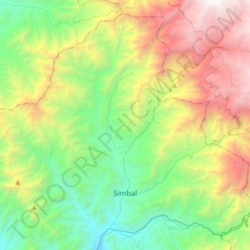
Name: Simbal topographic map, elevation, terrain.
Location: Simbal, Province of Trujillo, La Libertad, Peru (-8.01939 -78.94602 -7.79687 -78.69377)
Average elevation: 5,358 ft
Minimum elevation: 932 ft
Maximum elevation: 13,711 ft
Other topographic maps
Click on a map to view its topography, its elevation and its terrain.
Trujillo
Trujillo is located at an altitude of 34 metres (112 feet) on a coastal strip in the west of the province of Trujillo, in the old valley of Chimor today known as the Moche or Santa Catalina Valley. Its main square is located at 8°6′3″S 79°1′34″W / 8.10083°S 79.02611°W / -8.10083; -79.02611…
Average elevation: 699 ft