
Anthony topographic map
Click on the map to display elevation.
Anthony
Anthony has a desert climate, with a high degree of diurnal temperature variation due to the relatively high elevation and aridity.
About this map
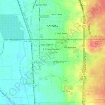
Name: Anthony topographic map, elevation, terrain.
Location: Anthony, El Paso County, Texas, 79821, United States (31.97565 -106.61682 32.01565 -106.57682)
Average elevation: 3,848 ft
Minimum elevation: 3,763 ft
Maximum elevation: 4,003 ft
El Paso County trails, hiking, mountain biking, running and outdoor activities
Other topographic maps
Click on a map to view its topography, its elevation and its terrain.
El Paso
United States > Texas > El Paso County
El Paso is characterized by a diverse and striking topography shaped by its desert environment and mountainous landscapes. The city is situated at an average elevation of approximately 3,700 feet above sea level, surrounded by the rugged Franklin Mountains to the west, where peaks exceed 7,000 feet. This…
Average elevation: 4,058 ft
Anthony
United States > Texas > El Paso County
Anthony has a desert climate, with a high degree of diurnal temperature variation due to the relatively high elevation and aridity.
Average elevation: 3,858 ft
El Paso
United States > Texas > El Paso County
El Paso County was established in March 1850, with San Elizario as the first county seat. The United States Senate fixed a boundary between Texas and New Mexico at the 32nd parallel, thus largely ignoring history and topography. A military post called the "Post opposite El Paso" (meaning opposite El Paso del…
Average elevation: 4,058 ft
Mc Arthur Park
United States > Texas > El Paso County > El Paso > Cielo Vista
Average elevation: 3,934 ft
El Paso
United States > Texas > El Paso County
El Paso County was established in March 1850, with San Elizario as the first county seat. The United States Senate fixed a boundary between Texas and New Mexico at the 32nd parallel, thus largely ignoring history and topography. A military post called the "Post opposite El Paso" (meaning opposite El Paso del…
Average elevation: 4,058 ft