
Anthony topographic map
Click on the map to display elevation.
Anthony
Anthony has a desert climate, with a high degree of diurnal temperature variation due to the relatively high elevation and aridity.
About this map
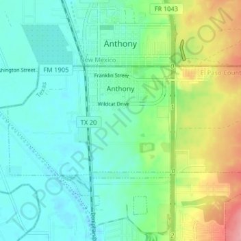
Name: Anthony topographic map, elevation, terrain.
Location: Anthony, El Paso County, Texas, 79821, United States (31.97582 -106.62711 32.00075 -106.56254)
Average elevation: 3,858 ft
Minimum elevation: 3,763 ft
Maximum elevation: 4,101 ft
El Paso County trails, hiking, mountain biking, running and outdoor activities
Other topographic maps
Click on a map to view its topography, its elevation and its terrain.
Rio Vista Addition Colonia
United States > Texas > El Paso County > Socorro
Average elevation: 3,661 ft
Anthony
United States > Texas > El Paso County
Anthony has a desert climate, with a high degree of diurnal temperature variation due to the relatively high elevation and aridity.
Average elevation: 3,848 ft
Mc Arthur Park
United States > Texas > El Paso County > El Paso > Cielo Vista
Average elevation: 3,934 ft
Colonia del Rio Number 1
United States > Texas > El Paso County > San Elizario
Average elevation: 3,635 ft