Geolocate

Tseminyu topographic map

Click on the map to display elevation.

About this map

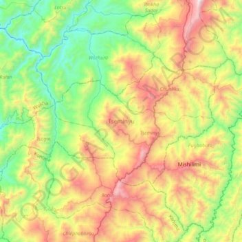
Name: Tseminyu topographic map, elevation, terrain.

Location: Tseminyu, Nagaland, 797109, India (25.86060 93.96526 26.02177 94.30048)

Average elevation: 2,723 ft

Minimum elevation: 492 ft

Maximum elevation: 6,381 ft

Other topographic maps

Click on a map to view its topography, its elevation and its terrain.

Tanhai

India > Nagaland > Mon

Average elevation: 2,310 ft

Chumukedima

India > Nagaland > Chumukedima

Average elevation: 823 ft

Chiephobozou

India > Nagaland > Chiephobozou

Average elevation: 3,901 ft

Mongsenyimti

India > Nagaland > Chuchuyimlang

Average elevation: 3,297 ft

Kohima

India > Nagaland > Kohima Sadar

Kohima district is the land of the Angami Naga and Rengma Naga tribe. It is situated in the foothills of Japfu range located south of Kohima District (25°40′N 94°07′E / 25.67°N 94.12°E / 25.67; 94.12) and has an average elevation of 1,261 metres (4137 feet).

Average elevation: 4,675 ft

Dimapur

India > Nagaland > Dimapur Sadar

Average elevation: 669 ft

Sechu Zubza

India > Nagaland > Sechu-Zubza > Sechu Zubza

Average elevation: 3,294 ft

Kigwema Town

India > Nagaland > Jakhama > Kigwema Town

Average elevation: 5,538 ft

Tsuruhu

India > Nagaland > Tsuruhu

Average elevation: 6,490 ft

Kohīma

India > Nagaland

Average elevation: 3,284 ft

Doyang

India > Nagaland > Sanis > Sanis

Average elevation: 1,811 ft

Doyang HEP Dam

India > Nagaland > Englan

Average elevation: 1,198 ft

Kiphire

India > Nagaland > Kiphire Sadar

Average elevation: 3,248 ft

Phek

India > Nagaland

Average elevation: 3,720 ft

Wokha

India > Nagaland

Average elevation: 2,359 ft

Mokokchung

India > Nagaland > ONGPANGKONG (N)

Mokokchung is located at 26°20′N 94°32′E / 26.33°N 94.53°E / 26.33; 94.53. It is located at an elevation of 1325 metres above sea level.

Average elevation: 3,369 ft

Gear up for your next adventure:

🌡️Handheld Weather Meters - Measure wind, temp, and pressure for safe mountain travel
🌡️Portable Weather Meter - Track weather conditions on the trail
🧭Hiking Compass - Precision compass for reliable navigation in the wilderness
🖼️Topo Map Wall Art - Decorative topographic prints of famous peaks and regions
🌧️Backpack Rain Cover - Keep gear dry in wet weather

As an Amazon Associate, this site earns from qualifying purchases at no extra cost to you.