
Kohīma topographic map
Click on the map to display elevation.
About this map
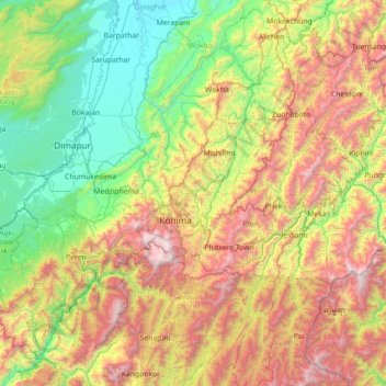
Name: Kohīma topographic map, elevation, terrain.
Location: Kohīma, Kohima, Nagaland, 797003, India (25.05000 93.46667 26.45000 94.86667)
Average elevation: 3,284 ft
Minimum elevation: 305 ft
Maximum elevation: 9,833 ft
Other topographic maps
Click on a map to view its topography, its elevation and its terrain.
Wokha
It covers an area of 1,628 sq. km. which equals around 9.82% of the total area of Nagaland. Of the total area, 35.74% comes under subtropical hill zone, 23.64% under subtropical plain zone and 40.59% in the mild tropical hill zone. The average altitude of the Wokha (Upper Range) is 1000-1500m above sea level;…
Average elevation: 1,529 ft