
Berwyn topographic map
Click on the map to display elevation.
Berwyn
According to the 2021 census gazetteer files, Berwyn has a total area of 3.90 square miles (10.10 km2), all land. Bordering cities include Oak Park to the north, Cicero to the east, Stickney to the south, Lyons, Riverside, North Riverside, and Forest Park to the west. Geologically, Berwyn is predominately composed of Glacial Lake Bottom from the Wisconsin Glacial Episode, the most recent glacial period. A beach ridge of sand and gravel, made during one of the stages of Lake Chicago, is also present in the city. This is most easily identified as Riverside Drive. The elevation change due to the ridge is clearly seen on the 2800 block of Maple Ave. Prior to the settlement of Berwyn, the land was grassy marshland. The body of water that connected the South Branch of the Chicago River to the Des Plaines River was a shallow waterway or a muddy slough (depending on the season) known as Mud Lake. Mud Lake extended nearly to the southern border of today's Berwyn, and the southern end of Berwyn flooded regularly during heavy rains in its early years.
About this map
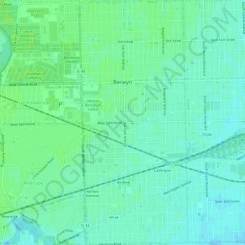
Name: Berwyn topographic map, elevation, terrain.
Location: Berwyn, Cook County, Illinois, United States (41.82115 -87.80422 41.86540 -87.77778)
Average elevation: 617 ft
Minimum elevation: 600 ft
Maximum elevation: 633 ft
Cook County trails, hiking, mountain biking, running and outdoor activities
Other topographic maps
Click on a map to view its topography, its elevation and its terrain.
North Pond Nature Sanctuary
United States > Illinois > Cook County > Chicago
Average elevation: 597 ft
Chicago, North Shore & Milwaukee
United States > Illinois > Cook County > Northbrook > Williamsburg Square
Average elevation: 650 ft