Geolocate

Palatine topographic map

Click on the map to display elevation.

About this map

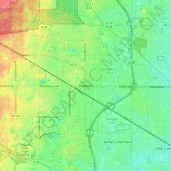
Name: Palatine topographic map, elevation, terrain.

Location: Palatine, Palatine Township, Cook County, Illinois, 60074, United States (42.07058 -88.07369 42.15058 -87.99369)

Average elevation: 748 ft

Minimum elevation: 673 ft

Maximum elevation: 873 ft

Cook County trails, hiking, mountain biking, running and outdoor activities

Other topographic maps

Click on a map to view its topography, its elevation and its terrain.

Chicago

United States > Illinois > Cook County

Chicago is characterized by its predominantly flat terrain, with an average elevation of about 579 feet (176 meters) above sea level. The city's landscape is primarily shaped by its proximity to Lake Michigan to the east, which influences local weather and provides a scenic waterfront. While the central areas…

Average elevation: 597 ft

Chicago

United States > Illinois > Cook County

When Chicago was founded in 1837, most of the early building was around the mouth of the Chicago River, as can be seen on a map of the city's original 58 blocks. The overall grade of the city's central, built-up areas is relatively consistent with the natural flatness of its overall natural geography,…

Average elevation: 597 ft

Evanston

United States > Illinois > Cook County

Average elevation: 604 ft

La Grange

United States > Illinois > Cook County

La Grange is located at 41°48′29″N 87°52′24″W / 41.80806°N 87.87333°W / 41.80806; -87.87333 (41.807938, −87.873455), about 13 miles (21 km) west of Chicago. The village is roughly flat, only deviating from the elevation of 645 feet by at most ten feet. La Grange is surrounded by…

Average elevation: 650 ft

Grant Park

United States > Illinois > Cook County > Chicago

Average elevation: 597 ft

Palos Park

United States > Illinois > Cook County

Average elevation: 656 ft

Oak Lawn

United States > Illinois > Cook County

Average elevation: 614 ft

Burnham

United States > Illinois > Cook County

Average elevation: 591 ft

Homewood

United States > Illinois > Cook County

Average elevation: 650 ft

Riis Park

United States > Illinois > Cook County > Chicago

Average elevation: 636 ft

Burnham

United States > Illinois > Cook County

Average elevation: 591 ft

Riverside

United States > Illinois > Cook County

Average elevation: 620 ft

Golf

United States > Illinois > Cook County

Average elevation: 640 ft

Kenilworth

United States > Illinois > Cook County

Average elevation: 617 ft

Barrington Hills

United States > Illinois > Cook County

Average elevation: 837 ft

Glencoe

United States > Illinois > Cook County

The village is surrounded on three sides by upper-income communities, with Highland Park on the north, Northbrook on the west, and Winnetka to the south. The Skokie Lagoons are located in the forest preserve to the immediate west of the village. The same forest preserve has a bicycle trail that connects to…

Average elevation: 636 ft

Westchester

United States > Illinois > Cook County

Average elevation: 643 ft

Palos Park

United States > Illinois > Cook County

Average elevation: 656 ft

Glenview

United States > Illinois > Cook County

Average elevation: 653 ft

Chicago

United States > Illinois > Cook County

When Chicago was founded in 1837, most of the early building was around the mouth of the Chicago River, as can be seen on a map of the city's original 58 blocks. The overall grade of the city's central, built-up areas is relatively consistent with the natural flatness of its overall natural geography,…

Average elevation: 597 ft

Beverly

United States > Illinois > Cook County > Chicago

Beverly, Morgan Park, Mount Greenwood, Washington Heights, and the City of Blue Island are considered part of the Blue Island Ridge. The prehistoric glacial ridge was once an island in a lake and later part of its western shore. The distinct geological history is the most significant in Chicago, being the…

Average elevation: 640 ft

Hillside

United States > Illinois > Cook County

Average elevation: 666 ft

Glenview

United States > Illinois > Cook County

Average elevation: 653 ft

Elk Grove Village

United States > Illinois > Cook County

Average elevation: 673 ft

Bellwood

United States > Illinois > Cook County

Average elevation: 643 ft

Evergreen Park

United States > Illinois > Cook County

Average elevation: 633 ft

Schaumburg

United States > Illinois > Cook County

According to the 2021 census gazetteer files, Schaumburg has a total area of 19.47 square miles (50.43 km2), of which 19.35 square miles (50.12 km2) (or 99.39%) is land and 0.12 square miles (0.31 km2) (or 0.61%) is water. Its elevation varies between 750 and 850 feet above sea level, with a high point of 850…

Average elevation: 778 ft

Western Springs

United States > Illinois > Cook County

Average elevation: 676 ft

Western Springs

United States > Illinois > Cook County

Average elevation: 676 ft

Uptown

United States > Illinois > Cook County > Chicago

Average elevation: 597 ft

Burbank

United States > Illinois > Cook County

Average elevation: 620 ft

Cumberland Park

United States > Illinois > Cook County > Park Ridge

Average elevation: 656 ft

Chicago

United States > Illinois > Cook County

When Chicago was founded in 1837, most of the early building was around the mouth of the Chicago River, as can be seen on a map of the city's original 58 blocks. The overall grade of the city's central, built-up areas is relatively consistent with the natural flatness of its overall natural geography,…

Average elevation: 597 ft

Stanton Park

United States > Illinois > Cook County > Chicago

Average elevation: 600 ft

Arlington Heights

United States > Illinois > Cook County

Average elevation: 702 ft

Flossmoor

United States > Illinois > Cook County

Average elevation: 682 ft

River Valley

United States > Illinois > Cook County > Northbrook

Average elevation: 650 ft

Willow Park

United States > Illinois > Cook County > Northfield

Average elevation: 640 ft

Skokie

United States > Illinois > Cook County

The Chicago "L"s Yellow Line terminates at the Dempster Street station in Skokie. Construction has been completed on a new Yellow Line train station at Oakton Street, to serve downtown Skokie. It opened on April 30, 2012. Additionally, the CTA is commissioning an alternatives analysis study on the extension of…

Average elevation: 623 ft

Chicago Ridge

United States > Illinois > Cook County

Average elevation: 607 ft

Inverness

United States > Illinois > Cook County

Average elevation: 827 ft

Garfield Park

United States > Illinois > Cook County > Chicago

Average elevation: 604 ft

Arlington Heights

United States > Illinois > Cook County

Average elevation: 702 ft

Schaumburg

United States > Illinois > Cook County

According to the 2021 census gazetteer files, Schaumburg has a total area of 19.47 square miles (50.43 km2), of which 19.35 square miles (50.12 km2) (or 99.39%) is land and 0.12 square miles (0.31 km2) (or 0.61%) is water. Its elevation varies between 750 and 850 feet above sea level, with a high point of 850…

Average elevation: 778 ft

Palatine

United States > Illinois > Cook County

Average elevation: 761 ft

Glencoe

United States > Illinois > Cook County

The village is surrounded on three sides by upper-income communities, with Highland Park on the north, Northbrook on the west, and Winnetka to the south. The Skokie Lagoons are located in the forest preserve to the immediate west of the village. The same forest preserve has a bicycle trail that connects to…

Average elevation: 636 ft

Prospect Heights

United States > Illinois > Cook County

Average elevation: 669 ft

Elmwood Park

United States > Illinois > Cook County

Average elevation: 640 ft

Willow Springs

United States > Illinois > Cook County

Average elevation: 656 ft

Palos Township

United States > Illinois > Cook County

Average elevation: 663 ft

Maine Township

United States > Illinois > Cook County

Average elevation: 650 ft

Chicago

United States > Illinois > Cook County

When Chicago was founded in 1837, most of the early building was around the mouth of the Chicago River, as can be seen on a map of the city's original 58 blocks. The overall grade of the city's central, built-up areas is relatively consistent with the natural flatness of its overall natural geography,…

Average elevation: 597 ft

Morton Grove

United States > Illinois > Cook County

Average elevation: 636 ft

Justice

United States > Illinois > Cook County

Average elevation: 627 ft

Prospect Heights

United States > Illinois > Cook County

Average elevation: 669 ft

Lyons

United States > Illinois > Cook County

Average elevation: 614 ft

Brookfield

United States > Illinois > Cook County

Average elevation: 627 ft

Hanover Park

United States > Illinois > Cook County

Average elevation: 801 ft

Park Ridge

United States > Illinois > Cook County

Average elevation: 650 ft

Oak Park

United States > Illinois > Cook County

Average elevation: 630 ft

Dolton

United States > Illinois > Cook County

Average elevation: 600 ft

Winnetka

United States > Illinois > Cook County

Average elevation: 620 ft

Chicago

United States > Illinois > Cook County

When Chicago was founded in 1837, most of the early building was around the mouth of the Chicago River, as can be seen on a map of the city's original 58 blocks. The overall grade of the city's central, built-up areas is relatively consistent with the natural flatness of its overall natural geography,…

Average elevation: 597 ft

Barrington

United States > Illinois > Cook County

Average elevation: 846 ft

Glencoe

United States > Illinois > Cook County

The village is surrounded on three sides by upper-income communities, with Highland Park on the north, Northbrook on the west, and Winnetka to the south. The Skokie Lagoons are located in the forest preserve to the immediate west of the village. The same forest preserve has a bicycle trail that connects to…

Average elevation: 636 ft

Midlothian

United States > Illinois > Cook County

Average elevation: 623 ft

Willow Springs

United States > Illinois > Cook County

Average elevation: 653 ft

Proviso Township

United States > Illinois > Cook County

Average elevation: 640 ft

Alsip

United States > Illinois > Cook County

Average elevation: 610 ft

Glenwood

United States > Illinois > Cook County

Average elevation: 623 ft

Kenilworth

United States > Illinois > Cook County

Average elevation: 617 ft

Palos Hills

United States > Illinois > Cook County

Average elevation: 614 ft

Park Forest

United States > Illinois > Cook County

Average elevation: 725 ft

Mount Prospect

United States > Illinois > Cook County

Average elevation: 673 ft

Hillside

United States > Illinois > Cook County

Average elevation: 666 ft

Barrington Hills

United States > Illinois > Cook County

Average elevation: 837 ft

Niles

United States > Illinois > Cook County

Average elevation: 646 ft

Riis Park

United States > Illinois > Cook County > Chicago

Average elevation: 636 ft

Olympia Fields

United States > Illinois > Cook County

Average elevation: 699 ft

Glenview

United States > Illinois > Cook County

Average elevation: 653 ft

Bedford Park

United States > Illinois > Cook County

Average elevation: 617 ft

Northfield

United States > Illinois > Cook County

Average elevation: 640 ft

Skokie

United States > Illinois > Cook County

The Chicago "L"s Yellow Line terminates at the Dempster Street station in Skokie. Construction has been completed on a new Yellow Line train station at Oakton Street, to serve downtown Skokie and environs. It opened on April 30, 2012. Additionally, the CTA is commissioning an Alternative Analysis Study on the…

Average elevation: 623 ft

River Forest

United States > Illinois > Cook County

Average elevation: 636 ft

Des Plaines

United States > Illinois > Cook County

Average elevation: 653 ft

Brookfield

United States > Illinois > Cook County

Average elevation: 627 ft

Orland Park

United States > Illinois > Cook County

Average elevation: 709 ft

Rosemont

United States > Illinois > Cook County

Average elevation: 640 ft

Elk Grove Village

United States > Illinois > Cook County

Average elevation: 673 ft

Niles

United States > Illinois > Cook County

Average elevation: 646 ft

La Grange

United States > Illinois > Cook County

La Grange is located at 41°48′29″N 87°52′24″W / 41.80806°N 87.87333°W / 41.80806; -87.87333 (41.807938, −87.873455), about 13 miles (21 km) west of Chicago. The village is roughly flat, only deviating from the elevation of 645 feet by at most ten feet. La Grange is surrounded by…

Average elevation: 653 ft

Wheeling

United States > Illinois > Cook County

Average elevation: 663 ft

Chicago

United States > Illinois > Cook County

When Chicago was founded in 1837, most of the early building was around the mouth of the Chicago River, as can be seen on a map of the city's original 58 blocks. The overall grade of the city's central, built-up areas is relatively consistent with the natural flatness of its overall natural geography,…

Average elevation: 597 ft

Inverness

United States > Illinois > Cook County

Average elevation: 830 ft

Steger

United States > Illinois > Cook County

Average elevation: 709 ft

Gear up for your next adventure:

GPS Sports Watch - GPS watch for running, hiking and training
👟Trail Running Shoes - Lightweight shoes for trail runners
🛡️Insect Repellent - Protection against bugs during outdoor activities
🖼️Topo Map Wall Art - Decorative topographic prints of famous peaks and regions
🚪Portable Camp Chair - Foldable chair for comfort at camp

As an Amazon Associate, this site earns from qualifying purchases at no extra cost to you.