Geolocate

Painesville topographic map

Click on the map to display elevation.

About this map

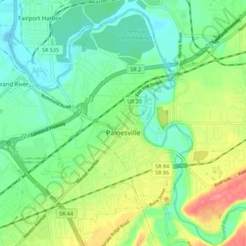
Name: Painesville topographic map, elevation, terrain.

Location: Painesville, Lake County, Ohio, 44077, United States (41.69952 -81.29252 41.75383 -81.21373)

Average elevation: 656 ft

Minimum elevation: 568 ft

Maximum elevation: 823 ft

Lake County trails, hiking, mountain biking, running and outdoor activities

Other topographic maps

Click on a map to view its topography, its elevation and its terrain.

Gildersleeve Mountain

United States > Ohio > Lake County > Kirtland

Average elevation: 991 ft

Waite Hill

United States > Ohio > Lake County > Waite Hill

Average elevation: 738 ft

Mentor

United States > Ohio > Lake County > Mentor > Mentor

Average elevation: 794 ft

Painesville

United States > Ohio > Lake County > Painesville > Painesville

Average elevation: 666 ft

South Madison

United States > Ohio > Lake County

Average elevation: 919 ft

Gear up for your next adventure:

🪶Paracord Bracelet - Survival bracelet with built‑in tools
🥾Men's Hiking Boots - Durable, waterproof footwear for rugged terrain and steep inclines
📷Action Cameras - Rugged cameras to document your journeys across rugged terrain
🥾Hiking Shoes - Durable and comfortable shoes for trail hiking
🪵Folding Camp Saw - Compact saw for wood and campsite work

As an Amazon Associate, this site earns from qualifying purchases at no extra cost to you.