Geolocate

Redmesa topographic map

Click on the map to display elevation.

About this map

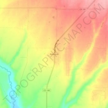
Name: Redmesa topographic map, elevation, terrain.

Location: Redmesa, La Plata County, Colorado, 81329, United States (37.07476 -108.19040 37.11476 -108.15040)

Average elevation: 6,519 ft

Minimum elevation: 6,257 ft

Maximum elevation: 6,693 ft

La Plata County trails, hiking, mountain biking, running and outdoor activities

Other topographic maps

Click on a map to view its topography, its elevation and its terrain.

Durango

United States > Colorado > La Plata County

Average elevation: 7,093 ft

Ignacio

United States > Colorado > La Plata County

Average elevation: 6,509 ft

Cherry Creek

United States > Colorado > La Plata County

Average elevation: 7,963 ft

Lake of the Pines

United States > Colorado > La Plata County

Average elevation: 9,137 ft

Missionary Ridge

United States > Colorado > La Plata County

Average elevation: 9,846 ft

Cherry Creek

United States > Colorado > La Plata County

Average elevation: 7,234 ft

Texas Creek

United States > Colorado > La Plata County > Columbus

Average elevation: 7,543 ft

Grimes Creek

United States > Colorado > La Plata County

Average elevation: 8,917 ft

Gear up for your next adventure:

🩳Quick‑Dry Hiking Shorts - Comfortable and quick‑dry shorts for summer hiking
🥩Freeze-Dried Meals - Nutritious and lightweight food for remote expeditions
📷Action Camera - Capture your outdoor adventures in HD
👟Trail Running Shoes - Lightweight shoes for trail runners
🗃️Trail First Aid Kit - Essential kit for outdoor injuries and emergencies

As an Amazon Associate, this site earns from qualifying purchases at no extra cost to you.