Geolocate

Ignacio topographic map

Click on the map to display elevation.

About this map

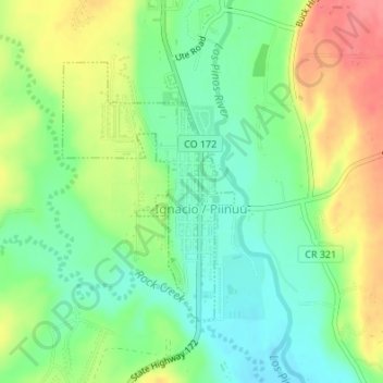
Name: Ignacio topographic map, elevation, terrain.

Location: Ignacio, La Plata County, Colorado, 81137, United States (37.10707 -107.64539 37.12534 -107.63014)

Average elevation: 6,509 ft

Minimum elevation: 6,411 ft

Maximum elevation: 6,647 ft

La Plata County trails, hiking, mountain biking, running and outdoor activities

Other topographic maps

Click on a map to view its topography, its elevation and its terrain.

Durango

United States > Colorado > La Plata County > Durango

Durango is located at 37°16′N 107°52′W / 37.267°N 107.867°W / 37.267; -107.867 at an elevation of 6,512 ft (1,988 m). At the 2020 United States Census, the town had a total area of 10,946 acres (44.296 km2) including 1,533 acres (6.203 km2) of water.

Average elevation: 7,743 ft

Redmesa

United States > Colorado > La Plata County

Average elevation: 6,519 ft

Cherry Creek

United States > Colorado > La Plata County

Average elevation: 7,963 ft

Missionary Ridge

United States > Colorado > La Plata County

Average elevation: 9,846 ft

Twin Buttes

United States > Colorado > La Plata County > Durango

Average elevation: 7,247 ft

Cherry Creek

United States > Colorado > La Plata County

Average elevation: 7,234 ft

Texas Creek

United States > Colorado > La Plata County > Columbus

Average elevation: 7,543 ft

Grimes Creek

United States > Colorado > La Plata County

Average elevation: 8,917 ft

Gear up for your next adventure:

🔦LED Headlamp - Bright and durable LED headlamp for night navigation
🪶Compact Camp Shovel - Folding shovel for campsite tasks
🌄Hiking Binoculars - Compact binoculars for scenic views and trail spotting
🚁Photography Drones - Capture stunning aerial views of landforms and topography
🎁Geography Themed Gifts - Unique gift ideas for map lovers and geography enthusiasts

As an Amazon Associate, this site earns from qualifying purchases at no extra cost to you.