
Make a donation
Gear up for your next adventure:
As an Amazon Associate, this site earns from qualifying purchases at no extra cost to you.
Cherry Creek topographic map
Click on the map to display elevation.
Make a donation
Gear up for your next adventure:
As an Amazon Associate, this site earns from qualifying purchases at no extra cost to you.
About this map
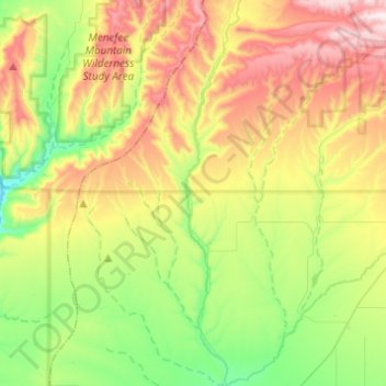
Name: Cherry Creek topographic map, elevation, terrain.
Location: Cherry Creek, La Plata County, Colorado, United States (37.11544 -108.22412 37.31032 -108.18890)
Average elevation: 7,234 ft
Minimum elevation: 6,148 ft
Maximum elevation: 8,842 ft
La Plata County trails, hiking, mountain biking, running and outdoor activities
Make a donation
Gear up for your next adventure:
As an Amazon Associate, this site earns from qualifying purchases at no extra cost to you.
Other topographic maps
Click on a map to view its topography, its elevation and its terrain.
Durango
United States > Colorado > La Plata County > Durango
Durango is located at 37°16′N 107°52′W / 37.267°N 107.867°W / 37.267; -107.867 at an elevation of 6,512 ft (1,988 m). At the 2020 United States Census, the town had a total area of 10,946 acres (44.296 km2) including 1,533 acres (6.203 km2) of water.
Average elevation: 7,743 ft
Make a donation
Gear up for your next adventure:
As an Amazon Associate, this site earns from qualifying purchases at no extra cost to you.