
Make a donation
Gear up for your next adventure:
As an Amazon Associate, this site earns from qualifying purchases at no extra cost to you.
Villa de Leyva topographic map
Click on the map to display elevation.
Make a donation
Gear up for your next adventure:
As an Amazon Associate, this site earns from qualifying purchases at no extra cost to you.
Villa de Leyva
Located away from major trade routes in a high altitude valley of semi-desert terrain, and with no mineral deposits nearby to exploit, the town has undergone little development in the last 400 years. As a consequence, it is one of the few towns in Colombia to have preserved much of its original colonial style and architecture: the streets and large central plaza are still paved with cobblestones, and many buildings date from the sixteenth century. This has resulted in Villa de Leyva becoming one of Colombia's principal tourist attractions, and it was declared a National Monument on December 17, 1954 to preserve its architecture. The town and the surrounding countryside, which contains several sites of interest, are popular weekend destinations for citizens of Bogota, and attract an increasing number of foreign tourists.
Make a donation
Gear up for your next adventure:
As an Amazon Associate, this site earns from qualifying purchases at no extra cost to you.
About this map
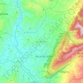
Name: Villa de Leyva topographic map, elevation, terrain.
Average elevation: 7,927 ft
Minimum elevation: 6,532 ft
Maximum elevation: 11,729 ft
Make a donation
Gear up for your next adventure:
As an Amazon Associate, this site earns from qualifying purchases at no extra cost to you.
Other topographic maps
Click on a map to view its topography, its elevation and its terrain.
Tunja
Tunja has a population of 172,548 inhabitants according to the 2018 Census. 0.1% of the city is indigenous, 0.4% is black, and 99.5% is white and Mestizo. It is located in central Colombia, at an elevation ranging from approximately 2,700 metres (8,900 ft) to 2,900 metres (9,500 ft). The city centre is at an…
Average elevation: 9,265 ft
Make a donation
Gear up for your next adventure:
As an Amazon Associate, this site earns from qualifying purchases at no extra cost to you.
Cordillera Oriental
The Cordillera Oriental montane forests ecoregion covers the eastern slopes of the cordillera and its northern end. The Magdalena Valley montane forests cover the western slopes. The Northern Andean páramo covers the highest elevations.
Average elevation: 15,830 ft
Sogamoso
Sogamoso (Spanish pronunciation: [soɣaˈmoso]) is a city in the department of Boyacá of Colombia. It is the capital of the Sugamuxi Province, named after the original Sugamuxi. Sogamoso is nicknamed "City of the Sun", based on the original Muisca tradition of pilgrimage and adoring their Sun god Sué at the…
Average elevation: 9,518 ft
Make a donation
Gear up for your next adventure:
As an Amazon Associate, this site earns from qualifying purchases at no extra cost to you.
Make a donation
Gear up for your next adventure:
As an Amazon Associate, this site earns from qualifying purchases at no extra cost to you.
Make a donation
Gear up for your next adventure:
As an Amazon Associate, this site earns from qualifying purchases at no extra cost to you.