
Make a donation
Gear up for your next adventure:
As an Amazon Associate, this site earns from qualifying purchases at no extra cost to you.
Sassafras Mountain topographic map
Click on the map to display elevation.
Make a donation
Gear up for your next adventure:
As an Amazon Associate, this site earns from qualifying purchases at no extra cost to you.
Sassafras Mountain
The Pisgah Quadrangle topographical map, revised 1904–1905, shows the long abandoned Sassafras Gap Road to be the preferred route through to Rosman, N.C. and Brevard, N.C. at the end of the 19th century and that the existing Highway 178 was then a secondary road. This abandoned road is a short distance from the summit and is crossed by the hiking trail to Caesars Head from Sassafras summit. Most people crossing this old roadbed in Sassafras Gap don't recognize it as a road, but it is easily recognized because of the short section of steps going down into the roadbed, and a similar section of short steps on the opposite side of the roadbed going up and the trail then continuing steeply up toward Caesars Head. A short hike South down the old Sassafras Gap Road will take you to Hickory Head Spring, the headwater of the South Saluda River. Hickory Head Spring is shown as a feature on the Mill's Atlas, 1825, Greenville District, South Carolina.
Make a donation
Gear up for your next adventure:
As an Amazon Associate, this site earns from qualifying purchases at no extra cost to you.
About this map
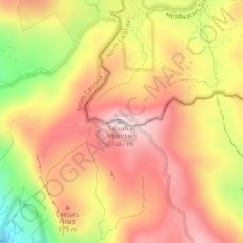
Name: Sassafras Mountain topographic map, elevation, terrain.
Average elevation: 2,936 ft
Minimum elevation: 2,047 ft
Maximum elevation: 3,514 ft
Pickens County trails, hiking, mountain biking, running and outdoor activities
Make a donation
Gear up for your next adventure:
As an Amazon Associate, this site earns from qualifying purchases at no extra cost to you.
Other topographic maps
Click on a map to view its topography, its elevation and its terrain.
Dawson Park
United States > South Carolina > Pickens County > Clemson > Briarwood
Average elevation: 764 ft
Make a donation
Gear up for your next adventure:
As an Amazon Associate, this site earns from qualifying purchases at no extra cost to you.
Table Rock State Park
United States > South Carolina > Pickens County > Pickens
Average elevation: 1,788 ft
Make a donation
Gear up for your next adventure:
As an Amazon Associate, this site earns from qualifying purchases at no extra cost to you.
Make a donation
Gear up for your next adventure:
As an Amazon Associate, this site earns from qualifying purchases at no extra cost to you.
Make a donation
Gear up for your next adventure:
As an Amazon Associate, this site earns from qualifying purchases at no extra cost to you.
Make a donation
Gear up for your next adventure:
As an Amazon Associate, this site earns from qualifying purchases at no extra cost to you.