Geolocate

Central topographic map

Click on the map to display elevation.

About this map
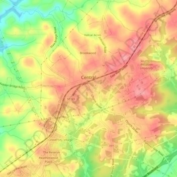
Name: Central topographic map, elevation, terrain.

Location: Central, Pickens County, South Carolina, United States (34.70205 -82.80521 34.74395 -82.75554)

Average elevation: 846 ft

Minimum elevation: 659 ft

Maximum elevation: 961 ft

Pickens County trails, hiking, mountain biking, running and outdoor activities

Other topographic maps

Click on a map to view its topography, its elevation and its terrain.
Pumpkintown

United States > South Carolina > Pickens County

Average elevation: 1,060 ft

Calhoun

United States > South Carolina > Pickens County > Clemson

Average elevation: 745 ft

Hendricks

United States > South Carolina > Pickens County

Average elevation: 1,086 ft

Jocassee Dam

United States > South Carolina > Pickens County

Average elevation: 1,024 ft

Sunset

United States > South Carolina > Pickens County

Average elevation: 1,253 ft

Sassafras Mountain

United States > South Carolina > Pickens County

The Pisgah Quadrangle topographical map, revised 1904–1905, shows the long abandoned Sassafras Gap Road to be the preferred route through to Rosman, N.C. and Brevard, N.C. at the end of the 19th century and that the existing Highway 178 was then a secondary road. This abandoned road is a short distance from…

Average elevation: 2,936 ft
Pleasant View

United States > South Carolina > Pickens County

Average elevation: 1,102 ft

Hillwood

United States > South Carolina > Pickens County

Average elevation: 1,043 ft

Canaan Land

United States > South Carolina > Pickens County > Easley

Average elevation: 1,030 ft

Crow Creek

United States > South Carolina > Pickens County

Average elevation: 1,076 ft

Dacusville

United States > South Carolina > Pickens County

Average elevation: 1,024 ft

Crow Creek

United States > South Carolina > Pickens County

Average elevation: 1,076 ft

Sassafras Mountain

United States > South Carolina > Pickens County

The Pisgah Quadrangle topographical map, revised 1904–1905, shows the long abandoned Sassafras Gap Road to be the preferred route through to Rosman, N.C. and Brevard, N.C. at the end of the 19th century and that the existing Highway 178 was then a secondary road. This abandoned road is a short distance from…

Average elevation: 2,936 ft
Calhoun

United States > South Carolina > Pickens County > Clemson

Average elevation: 745 ft

Beverly Hills

United States > South Carolina > Pickens County

Average elevation: 1,027 ft

North Hills

United States > South Carolina > Pickens County > Easley

Average elevation: 1,056 ft

Sunset

United States > South Carolina > Pickens County

Average elevation: 1,253 ft

Twin Falls

United States > South Carolina > Pickens County

Average elevation: 1,506 ft

Gear up for your next adventure:

📷Action Cameras - Rugged cameras to document your journeys across rugged terrain
🎒Day Hiking Backpack - Lightweight backpack perfect for day trips and outdoor adventures
🧥Waterproof Jacket for Hiking - Breathable and rugged rain jacket for outdoor excursions
📦Gear Storage Bags - Organize and protect outdoor equipment
🔥Plasma Lighters - Windproof lighters that work in any weather condition

As an Amazon Associate, this site earns from qualifying purchases at no extra cost to you.