
Make a donation
Gear up for your next adventure:
As an Amazon Associate, this site earns from qualifying purchases at no extra cost to you.
Six Mile topographic map
Click on the map to display elevation.
Make a donation
Gear up for your next adventure:
As an Amazon Associate, this site earns from qualifying purchases at no extra cost to you.
About this map
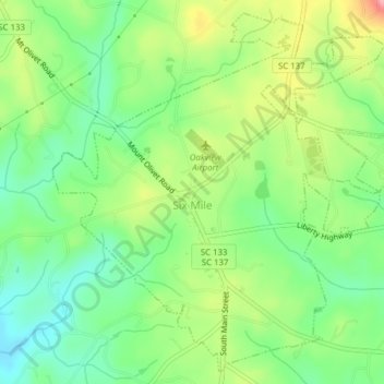
Name: Six Mile topographic map, elevation, terrain.
Location: Six Mile, Pickens County, South Carolina, United States (34.79358 -82.83415 34.82329 -82.79539)
Average elevation: 1,004 ft
Minimum elevation: 846 ft
Maximum elevation: 1,194 ft
Pickens County trails, hiking, mountain biking, running and outdoor activities
Make a donation
Gear up for your next adventure:
As an Amazon Associate, this site earns from qualifying purchases at no extra cost to you.
Other topographic maps
Click on a map to view its topography, its elevation and its terrain.
Dawson Park
United States > South Carolina > Pickens County > Clemson > Briarwood
Average elevation: 764 ft
Make a donation
Gear up for your next adventure:
As an Amazon Associate, this site earns from qualifying purchases at no extra cost to you.
Sassafras Mountain
United States > South Carolina > Pickens County
The Pisgah Quadrangle topographical map, revised 1904–1905, shows the long abandoned Sassafras Gap Road to be the preferred route through to Rosman, N.C. and Brevard, N.C. at the end of the 19th century and that the existing Highway 178 was then a secondary road. This abandoned road is a short distance from…
Average elevation: 2,936 ft
Make a donation
Gear up for your next adventure:
As an Amazon Associate, this site earns from qualifying purchases at no extra cost to you.
Make a donation
Gear up for your next adventure:
As an Amazon Associate, this site earns from qualifying purchases at no extra cost to you.
Make a donation
Gear up for your next adventure:
As an Amazon Associate, this site earns from qualifying purchases at no extra cost to you.
Sassafras Mountain
United States > South Carolina > Pickens County
The Pisgah Quadrangle topographical map, revised 1904–1905, shows the long abandoned Sassafras Gap Road to be the preferred route through to Rosman, N.C. and Brevard, N.C. at the end of the 19th century and that the existing Highway 178 was then a secondary road. This abandoned road is a short distance from…
Average elevation: 2,936 ft
Make a donation
Gear up for your next adventure:
As an Amazon Associate, this site earns from qualifying purchases at no extra cost to you.
Clemson Heights
United States > South Carolina > Pickens County > Clemson > Clemson Heights
Average elevation: 712 ft