
Make a donation
Gear up for your next adventure:
As an Amazon Associate, this site earns from qualifying purchases at no extra cost to you.
Ötigheim topographic map
Click on the map to display elevation.
Make a donation
Gear up for your next adventure:
As an Amazon Associate, this site earns from qualifying purchases at no extra cost to you.
About this map
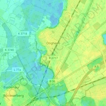
Name: Ötigheim topographic map, elevation, terrain.
Average elevation: 384 ft
Minimum elevation: 354 ft
Maximum elevation: 410 ft
Make a donation
Gear up for your next adventure:
As an Amazon Associate, this site earns from qualifying purchases at no extra cost to you.
Other topographic maps
Click on a map to view its topography, its elevation and its terrain.
Schwarzenbachtalsperre
Deutschland > Baden-Württemberg > Landkreis Rastatt > Forbach
Der Stausee sammelt das Wasser am Ostabhang des niederschlagsreichen Hauptkamms des nördlichen Schwarzwalds, unterhalb von Hornisgrinde, Mehliskopf und Badener Höhe. Der Schwarzenbach und der Seebach werden direkt gestaut, das Wasser der Bäche Biberach und Hundsbach (Quellbäche der Raumünzach) wird per…
Average elevation: 2,293 ft
Make a donation
Gear up for your next adventure:
As an Amazon Associate, this site earns from qualifying purchases at no extra cost to you.
Teufelsmühle
Deutschland > Baden-Württemberg > Landkreis Rastatt > Gernsbach
Average elevation: 2,408 ft
Streitmannskopf
Deutschland > Baden-Württemberg > Landkreis Rastatt > Forbach
Average elevation: 2,546 ft
Make a donation
Gear up for your next adventure:
As an Amazon Associate, this site earns from qualifying purchases at no extra cost to you.
Selbach
Deutschland > Baden-Württemberg > Landkreis Rastatt > Gaggenau > Selbach
Average elevation: 755 ft
Make a donation
Gear up for your next adventure:
As an Amazon Associate, this site earns from qualifying purchases at no extra cost to you.
Schwarzwasen
Deutschland > Baden-Württemberg > Landkreis Rastatt > Bühlertal
Average elevation: 1,457 ft
Steckenhalt
Deutschland > Baden-Württemberg > Landkreis Rastatt > Bühlertal
Average elevation: 1,631 ft
Make a donation
Gear up for your next adventure:
As an Amazon Associate, this site earns from qualifying purchases at no extra cost to you.
Sand
Deutschland > Baden-Württemberg > Landkreis Rastatt > Bühl
Der Sand ist eine zur Stadt Bühl gehörende Häusergruppe an der Schwarzwaldhochstraße (B 500) unterhalb des Mehliskopfes. Sie liegt im Nordschwarzwald auf einer Höhe von 824 m ü. NHN.
Average elevation: 2,641 ft
Make a donation
Gear up for your next adventure:
As an Amazon Associate, this site earns from qualifying purchases at no extra cost to you.
Freiolsheim
Deutschland > Baden-Württemberg > Landkreis Rastatt > Gaggenau
Average elevation: 1,398 ft
Make a donation
Gear up for your next adventure:
As an Amazon Associate, this site earns from qualifying purchases at no extra cost to you.
Hundseck
Deutschland > Baden-Württemberg > Landkreis Rastatt > Ottersweier
Average elevation: 2,746 ft
Make a donation
Gear up for your next adventure:
As an Amazon Associate, this site earns from qualifying purchases at no extra cost to you.
Hundsbach-Aschenplatz
Deutschland > Baden-Württemberg > Landkreis Rastatt > Forbach
Average elevation: 2,740 ft
Korbmatten Baden-Baden
Deutschland > Baden-Württemberg > Landkreis Rastatt > Baden-Baden > Steinbach
Average elevation: 446 ft
Make a donation
Gear up for your next adventure:
As an Amazon Associate, this site earns from qualifying purchases at no extra cost to you.
Badener Höhe
Deutschland > Baden-Württemberg > Landkreis Rastatt > Forbach
Average elevation: 2,697 ft
Oberweier
Deutschland > Baden-Württemberg > Landkreis Rastatt > Bühl > Oberweier
Average elevation: 433 ft
Make a donation
Gear up for your next adventure:
As an Amazon Associate, this site earns from qualifying purchases at no extra cost to you.
Talhof
Deutschland > Baden-Württemberg > Landkreis Rastatt > Gaggenau > Moosbronn
Average elevation: 1,483 ft
Make a donation
Gear up for your next adventure:
As an Amazon Associate, this site earns from qualifying purchases at no extra cost to you.