
Make a donation
Gear up for your next adventure:
As an Amazon Associate, this site earns from qualifying purchases at no extra cost to you.
Kleiner Lindleinsee topographic map
Click on the map to display elevation.
Make a donation
Gear up for your next adventure:
As an Amazon Associate, this site earns from qualifying purchases at no extra cost to you.
About this map
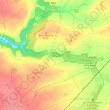
Name: Kleiner Lindleinsee topographic map, elevation, terrain.
Average elevation: 1,339 ft
Minimum elevation: 1,168 ft
Maximum elevation: 1,440 ft
Make a donation
Gear up for your next adventure:
As an Amazon Associate, this site earns from qualifying purchases at no extra cost to you.
Other topographic maps
Click on a map to view its topography, its elevation and its terrain.
Detwang
Deutschland > Bayern > Landkreis Ansbach > Rothenburg ob der Tauber
Average elevation: 1,358 ft
Hemmendorf
Deutschland > Bayern > Landkreis Ansbach > Rothenburg ob der Tauber
Average elevation: 1,457 ft
Brundorf
Deutschland > Bayern > Landkreis Ansbach > Rothenburg ob der Tauber > Leuzenbronn
Average elevation: 1,444 ft
Make a donation
Gear up for your next adventure:
As an Amazon Associate, this site earns from qualifying purchases at no extra cost to you.
Reusch
Deutschland > Bayern > Landkreis Ansbach > Rothenburg ob der Tauber > Bettenfeld
Etwa einen Kilometer nordöstlich des Weilers liegt die Bossendorfer Höhe (467 m ü. NHN), 1 km südöstlich liegt die Schandtauberhöhle, die zugleich ein Naturschutzgebiet ist. Gemeindeverbindungsstraßen führen nach Bossendorf zur Landesstraße 1022 (1 km nördlich), zur L 1005 bei Leuzendorf (1,2 km…
Average elevation: 1,493 ft
Schnepfendorf
Deutschland > Bayern > Landkreis Ansbach > Rothenburg ob der Tauber
Average elevation: 1,476 ft