Geolocate

Iatan topographic map

Click on the map to display elevation.

About this map

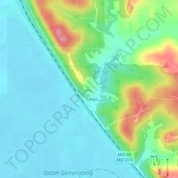
Name: Iatan topographic map, elevation, terrain.

Location: Iatan, Platte County, Missouri, United States (39.47324 -94.98874 39.48035 -94.97916)

Average elevation: 860 ft

Minimum elevation: 771 ft

Maximum elevation: 1,093 ft

Platte County trails, hiking, mountain biking, running and outdoor activities

Other topographic maps

Click on a map to view its topography, its elevation and its terrain.

Sadler

United States > Missouri > Platte County

Average elevation: 827 ft

Waldron

United States > Missouri > Platte County

Average elevation: 830 ft

Parkville

United States > Missouri > Platte County > Parkville > Parkville

Average elevation: 856 ft

Gear up for your next adventure:

🔪Outdoor Multitools - Essential survival tools for gear repair and field use
🔥Camping Stove - Portable stove for camping and backcountry cooking
📷Action Camera - Capture your outdoor adventures in HD
📦Gear Storage Bags - Organize and protect outdoor equipment
🔭Stargazing Telescopes - Perfect for camping in low-light pollution areas shown on maps

As an Amazon Associate, this site earns from qualifying purchases at no extra cost to you.