
Make a donation
Gear up for your next adventure:
As an Amazon Associate, this site earns from qualifying purchases at no extra cost to you.
Yakima Peak topographic map
Click on the map to display elevation.
Make a donation
Gear up for your next adventure:
As an Amazon Associate, this site earns from qualifying purchases at no extra cost to you.
About this map
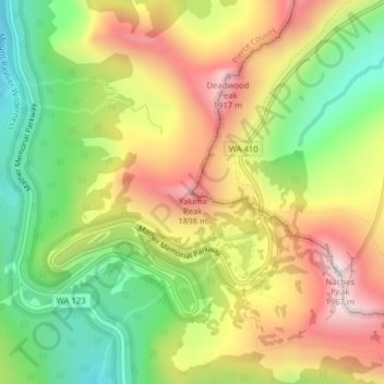
Name: Yakima Peak topographic map, elevation, terrain.
Location: Yakima Peak, Pierce County, Washington, United States (46.87332 -121.52276 46.87342 -121.52266)
Average elevation: 5,220 ft
Minimum elevation: 4,203 ft
Maximum elevation: 6,335 ft
Pierce County trails, hiking, mountain biking, running and outdoor activities
Make a donation
Gear up for your next adventure:
As an Amazon Associate, this site earns from qualifying purchases at no extra cost to you.
Other topographic maps
Click on a map to view its topography, its elevation and its terrain.
Make a donation
Gear up for your next adventure:
As an Amazon Associate, this site earns from qualifying purchases at no extra cost to you.
Make a donation
Gear up for your next adventure:
As an Amazon Associate, this site earns from qualifying purchases at no extra cost to you.
Mowich Lake
United States > Washington > Pierce County
Mowich Lake is a lake located in the northwestern corner of Mount Rainier National Park in Washington state at an elevation of 4,929 feet (1,502 m). The name "Mowich" derives from the Chinook jargon word for deer.
Average elevation: 5,121 ft
Make a donation
Gear up for your next adventure:
As an Amazon Associate, this site earns from qualifying purchases at no extra cost to you.
Eagle Island Marine State Park
United States > Washington > Pierce County > Johnson Landing
Average elevation: 69 ft
Make a donation
Gear up for your next adventure:
As an Amazon Associate, this site earns from qualifying purchases at no extra cost to you.