Geolocate

Midland topographic map

Click on the map to display elevation.

About this map

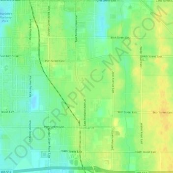
Name: Midland topographic map, elevation, terrain.

Location: Midland, Pierce County, Washington, United States (47.15812 -122.43569 47.19180 -122.39619)

Average elevation: 413 ft

Minimum elevation: 371 ft

Maximum elevation: 456 ft

Pierce County trails, hiking, mountain biking, running and outdoor activities

Other topographic maps

Click on a map to view its topography, its elevation and its terrain.

Sunrise

United States > Washington > Pierce County

Average elevation: 5,758 ft

Glencove

United States > Washington > Pierce County

Average elevation: 141 ft

Yakima Peak

United States > Washington > Pierce County

Average elevation: 5,220 ft

Hope

United States > Washington > Pierce County > Fox Island

Average elevation: 85 ft

Paul Peak

United States > Washington > Pierce County

Average elevation: 3,688 ft

Fife Heights

United States > Washington > Pierce County

Average elevation: 135 ft

Browns Point

United States > Washington > Pierce County

Average elevation: 59 ft

Purdy

United States > Washington > Pierce County

Average elevation: 174 ft

Ashford

United States > Washington > Pierce County

Average elevation: 2,169 ft

Eatonville

United States > Washington > Pierce County > Eatonville

Average elevation: 1,073 ft

Buckley

United States > Washington > Pierce County > Buckley > Buckley

Average elevation: 771 ft

Fairfax

United States > Washington > Pierce County

Average elevation: 1,772 ft

Arletta

United States > Washington > Pierce County > Artondale

Average elevation: 108 ft

Kapowsin

United States > Washington > Pierce County

Average elevation: 696 ft

Alderton

United States > Washington > Pierce County

Average elevation: 177 ft

North Puyallup

United States > Washington > Pierce County

Average elevation: 151 ft

Glacier View

United States > Washington > Pierce County

Average elevation: 4,318 ft

Tanwax

United States > Washington > Pierce County > Graham

Average elevation: 696 ft

Longbranch

United States > Washington > Pierce County

Average elevation: 121 ft

DuPont

United States > Washington > Pierce County > DuPont > DuPont

Average elevation: 236 ft

Custer

United States > Washington > Pierce County > Lakewood > Custer

Average elevation: 243 ft

Copper Mountain

United States > Washington > Pierce County

Average elevation: 5,299 ft

Graham

United States > Washington > Pierce County > Graham

Average elevation: 666 ft

Reliance

United States > Washington > Pierce County

Average elevation: 1,506 ft

Lakewood

United States > Washington > Pierce County > Lakewood > Lakewood

Average elevation: 262 ft

Old Baldy Mountain

United States > Washington > Pierce County

Average elevation: 4,288 ft

Gear up for your next adventure:

🖼️Topo Map Wall Art - Decorative topographic prints of famous peaks and regions
📦Gear Storage Bags - Organize and protect outdoor equipment
🪶Paracord Bracelet - Survival bracelet with built‑in tools
👟Men's Trail Runners - Lightweight footwear for fast-paced exploration and light hiking
🥩Freeze-Dried Meals - Nutritious and lightweight food for remote expeditions

As an Amazon Associate, this site earns from qualifying purchases at no extra cost to you.