Geolocate

Maple Springs topographic map

Click on the map to display elevation.

About this map

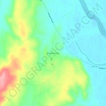
Name: Maple Springs topographic map, elevation, terrain.

Location: Maple Springs, Independence County, Arkansas, 72571, United States (35.61536 -91.53069 35.65536 -91.49069)

Average elevation: 335 ft

Minimum elevation: 217 ft

Maximum elevation: 587 ft

Independence County trails, hiking, mountain biking, running and outdoor activities

Other topographic maps

Click on a map to view its topography, its elevation and its terrain.

Southside

United States > Arkansas > Independence County

The elevation of Southside is 354 feet (108 m).

Average elevation: 367 ft

Cushman

United States > Arkansas > Independence County

Average elevation: 653 ft

Magness

United States > Arkansas > Independence County

Average elevation: 279 ft

Moorefield

United States > Arkansas > Independence County

Average elevation: 358 ft

Oil Trough

United States > Arkansas > Independence County

Average elevation: 233 ft

Gear up for your next adventure:

🛡️Insect Repellent - Protection against bugs during outdoor activities
🥾Hiking Shoes - Durable and comfortable shoes for trail hiking
🏕️Family Camping Gear - Essentials for group camping trips
🥾Men's Hiking Boots - Durable, waterproof footwear for rugged terrain and steep inclines
🧭Outdoor Navigation Book - Learn advanced navigation skills

As an Amazon Associate, this site earns from qualifying purchases at no extra cost to you.