Geolocate

Cushman topographic map

Click on the map to display elevation.

About this map

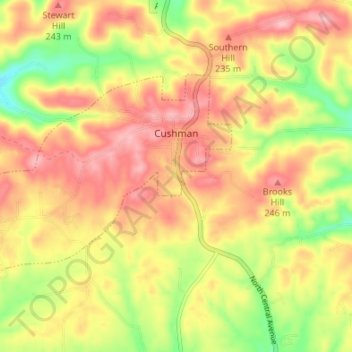
Name: Cushman topographic map, elevation, terrain.

Location: Cushman, Independence County, Arkansas, 72526, United States (35.85163 -91.81098 35.88316 -91.74361)

Average elevation: 653 ft

Minimum elevation: 390 ft

Maximum elevation: 846 ft

Independence County trails, hiking, mountain biking, running and outdoor activities

Other topographic maps

Click on a map to view its topography, its elevation and its terrain.

Cord

United States > Arkansas > Independence County

Average elevation: 305 ft

Desha

United States > Arkansas > Independence County

Average elevation: 318 ft

Gainsboro

United States > Arkansas > Independence County

Average elevation: 430 ft

Bethesda

United States > Arkansas > Independence County

Average elevation: 548 ft

Salado

United States > Arkansas > Independence County

Average elevation: 374 ft

Bryant

United States > Arkansas > Independence County > Southside

Average elevation: 358 ft

Charlotte

United States > Arkansas > Independence County

Average elevation: 404 ft

Limedale

United States > Arkansas > Independence County

Average elevation: 456 ft

Pfeiffer

United States > Arkansas > Independence County

Average elevation: 453 ft

Thida

United States > Arkansas > Independence County

Average elevation: 315 ft

Cushman

United States > Arkansas > Independence County > Cushman > Cushman

Average elevation: 679 ft

Floral

United States > Arkansas > Independence County

Average elevation: 774 ft

Gear up for your next adventure:

🎒Outdoor Daypacks - Lightweight backpacks designed for carrying maps and essential gear
🥄Camping Utensil Set - Lightweight utensils for outdoor meals
🔦Compact Flashlight - Reliable flashlight for emergencies
GPS Sports Watch - GPS watch for running, hiking and training
🧣Hiking Neck Gaiter - Multi‑use neck protection for outdoor weather

As an Amazon Associate, this site earns from qualifying purchases at no extra cost to you.