Geolocate

Benson topographic map

Click on the map to display elevation.

About this map

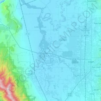
Name: Benson topographic map, elevation, terrain.

Location: Benson, Cache County, Utah, United States (41.66180 -111.95920 41.83997 -111.85999)

Average elevation: 4,731 ft

Minimum elevation: 4,400 ft

Maximum elevation: 8,727 ft

Cache County trails, hiking, mountain biking, running and outdoor activities

Other topographic maps

Click on a map to view its topography, its elevation and its terrain.

Hyrum

United States > Utah > Cache County > Hyrum > Hyrum

Average elevation: 4,721 ft

Greenville

United States > Utah > Cache County > North Logan

Average elevation: 4,557 ft

Mount Pisgah

United States > Utah > Cache County

Average elevation: 6,109 ft

Bald Head

United States > Utah > Cache County

Average elevation: 6,378 ft

Providence Canyon

United States > Utah > Cache County

Average elevation: 6,001 ft

Logan

United States > Utah > Cache County > Logan > Logan

Average elevation: 4,656 ft

Gear up for your next adventure:

💧Water Purification System - Clean water on the trail with reliable purifiers
🚑Emergency Bivvies - Heat-reflective sleeping bags for survival situations
🗺️Topographic Maps - Detailed topo maps for hiking, exploring and outdoor navigation
🧣Hiking Neck Gaiter - Multi‑use neck protection for outdoor weather
❄️Traction Cleats - Prevent slips on icy trails during winter hikes

As an Amazon Associate, this site earns from qualifying purchases at no extra cost to you.