
Make a donation
Gear up for your next adventure:
As an Amazon Associate, this site earns from qualifying purchases at no extra cost to you.
Bonga topographic map
Click on the map to display elevation.
Make a donation
Gear up for your next adventure:
As an Amazon Associate, this site earns from qualifying purchases at no extra cost to you.
Bonga
Bonga is a town, woreda and one of the multicapital of the South West Ethiopia Peoples' Region in Ethiopia. Located in the Keffa Zone upon a hill in the upper Barta valley, it has a latitude and longitude of 7°16′N 36°14′E / 7.267°N 36.233°E / 7.267; 36.233 with an elevation of 1,714 meters above sea level. Not confused with another town named "Bonga", near Gambela Region.
Make a donation
Gear up for your next adventure:
As an Amazon Associate, this site earns from qualifying purchases at no extra cost to you.
About this map
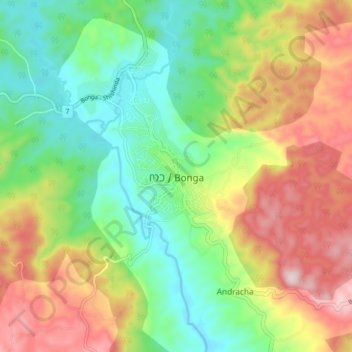
Name: Bonga topographic map, elevation, terrain.
Location: Bonga, Keffa, South West Ethiopia Peoples, Ethiopia (7.22454 36.20605 7.30454 36.28605)
Average elevation: 5,804 ft
Minimum elevation: 5,167 ft
Maximum elevation: 6,726 ft
Make a donation
Gear up for your next adventure:
As an Amazon Associate, this site earns from qualifying purchases at no extra cost to you.
Other topographic maps
Click on a map to view its topography, its elevation and its terrain.
Addis Ababa
Addis Ababa lies at an elevation of 2,355 metres (7,726 ft) and is a grassland biome, located at 9°1′48″N 38°44′24″E / 9.03000°N 38.74000°E / 9.03000; 38.74000. The city lies at the foot of Mount Entoto and forms part of the watershed for the Awash. From its lowest point, around Bole…
Average elevation: 7,779 ft
Make a donation
Gear up for your next adventure:
As an Amazon Associate, this site earns from qualifying purchases at no extra cost to you.
Simien Mountains National Park
The vegetation is mixed with African alpine forests, wilderness forests and alpine vegetation. High altitude areas include montane savannah and tree heath (Erica arborea), giant lobelia (Lobelia rhynchopetalum), yellow primrose (Primula verticillata), everlastings (Helichrysum spp.), a lady's mantle…
Average elevation: 7,667 ft
Tigray
Of the 10 largest cities in Tigray, Maychew has the highest elevation at 2479 meter above sea level. Plenty of smaller towns, like Atsbi and Edaga Hamus are located at even higher elevations. Of the large cities, Humera is located at the lowest altitude (585 m).
Average elevation: 4,416 ft
Make a donation
Gear up for your next adventure:
As an Amazon Associate, this site earns from qualifying purchases at no extra cost to you.
Mek'elē
Mekelle (Tigrinya: መቐለ), or Mek'ele, is a special zone and capital of the Tigray Region of Ethiopia. Mekelle was formerly the capital of Enderta awraja in Tigray. It is located around 780 kilometres (480 mi) north of the Ethiopian capital Addis Ababa, with an elevation of 2,254 metres (7,395 ft) above…
Average elevation: 6,857 ft
Make a donation
Gear up for your next adventure:
As an Amazon Associate, this site earns from qualifying purchases at no extra cost to you.
Make a donation
Gear up for your next adventure:
As an Amazon Associate, this site earns from qualifying purchases at no extra cost to you.
Nech Sar National Park
Ethiopia > South Ethiopia Regional State > Arba Minch
Average elevation: 3,986 ft
Make a donation
Gear up for your next adventure:
As an Amazon Associate, this site earns from qualifying purchases at no extra cost to you.
Make a donation
Gear up for your next adventure:
As an Amazon Associate, this site earns from qualifying purchases at no extra cost to you.
Lake Hawassa
Lake Hawassa or Awasa, is an endorheic basin in Sidama Region of Ethiopia, located in the Main Ethiopian Rift south of Addis Ababa, the capital city of the country. According to the Statistical Abstract of Ethiopia for 1967/68, the lake is 16 km long and 9 km wide, with a surface area of 129 square kilometers.…
Average elevation: 5,594 ft
Make a donation
Gear up for your next adventure:
As an Amazon Associate, this site earns from qualifying purchases at no extra cost to you.
Grand Ethiopian Renaissance Dam
Ethiopia > Benishangul-Gumuz Region
The first phase of filling the reservoir began in July 2020 and in August 2020 the water level rose to an altitude of 540 meters (40 meters higher than the bottom of the river, which is at an altitude of 500 meters above sea level). The second phase of filling was completed on 19 July 2021, with water levels…
Average elevation: 1,821 ft
Tigray
Of the 10 largest cities in Tigray, Maychew has the highest elevation at 2479 meter above sea level. Plenty of smaller towns, like Atsbi and Edaga Hamus are located at even higher elevations. Of the large cities, Humera is located at the lowest altitude (585 m).
Average elevation: 4,416 ft
Bombe
Ethiopia > South Ethiopia Regional State
Bombe (Geʽez: ቦምቤ) is a town and separate district in Wolayita Zone of the South Ethiopia Regional State, Ethiopia. Bombe town is located 325 km (202 mi) and 55 km (34 mi) away from Addis Ababa and Wolaita Sodo town through Hossana exit, respectively. Bombe town is used as an administrative capital of…
Average elevation: 4,977 ft
Sidama
Sidama has a variety of climatic conditions. Warm conditions cover 54% of the area. Locally known as Gamoojje or Woinadega, this is a temperate zone ranging from an elevation of 1500 m to 2500 m above sea level. The mean annual rainfall of the area varies between 1200 mm and 1599 mm, with 15 °C to 19.9 °C…
Average elevation: 6,785 ft
Make a donation
Gear up for your next adventure:
As an Amazon Associate, this site earns from qualifying purchases at no extra cost to you.
Make a donation
Gear up for your next adventure:
As an Amazon Associate, this site earns from qualifying purchases at no extra cost to you.
Boditi
Ethiopia > South Ethiopia Regional State
Boditi, (Amharic: ቦዲቲ) or (Wolayttattuwa: Bodditte) is a city and separate district in south central Ethiopia. The city is located in the Wolaita Zone of the South Ethiopia Regional State. This city has a latitude and longitude of 6°58′N 37°52′E / 6.967°N 37.867°E / 6.967; 37.867 with an…
Average elevation: 6,503 ft
Make a donation
Gear up for your next adventure:
As an Amazon Associate, this site earns from qualifying purchases at no extra cost to you.
Simien Mountains National Park
The vegetation is mixed with African alpine forests, wilderness forests and alpine vegetation. High altitude areas include montane savannah and tree heath (Erica arborea), giant lobelia (Lobelia rhynchopetalum), yellow primrose (Primula verticillata), everlastings (Helichrysum spp.), A lady's mantle…
Average elevation: 7,667 ft
Make a donation
Gear up for your next adventure:
As an Amazon Associate, this site earns from qualifying purchases at no extra cost to you.
Awi Agew
Topographically speaking, Agaw Awi is relatively flat and fertile, whose elevations vary from 1,800 to 3,100 m above sea level, with an average altitude of about 2,300 m. The Zone is crossed by about nine permanent rivers which drain into the Abay (or Blue Nile); other water features include two crater lakes,…
Average elevation: 5,381 ft
Addis Ababa
Moreover, the city held strong social organization patterns prior to the Italian invasion. According to Richard Pankhurst (1968), the city's accelerated population growth was due to factors of provisional governors and their troops, the 1892 famine, and eventually the Battle of Adwa. Another includes the 1907…
Average elevation: 7,779 ft
Make a donation
Gear up for your next adventure:
As an Amazon Associate, this site earns from qualifying purchases at no extra cost to you.
Asela
Asella (Oromo: Asallaa, Amharic: አሰላ) is a town in central Ethiopia. Located in the Arsi Zone of the Oromia Region 156 km (97 mi) south from Addis Ababa, this town has a latitude and longitude of 7°57′N 39°7′E / 7.950°N 39.117°E / 7.950; 39.117, with an elevation of 2,430 meters. Asella…
Average elevation: 7,969 ft
Addis Ababa
Moreover, the city held strong social organization patterns prior to the Italian invasion. According to Richard Pankhurst (1968), the city's accelerated population growth was due to factors of provisional governors and their troops, the 1892 famine, and eventually the Battle of Adwa. Another includes the 1907…
Average elevation: 7,779 ft
Lake Abaya
The only outflow of the lake is through the lower reaches of Kulfo River directly below an alluvial fan at an elevation of 1,190 m (at 6°00′39″N 37°35′07″E / 6.0109°N 37.5854°E / 6.0109; 37.5854). The riverbed acts as an spillway in the case of high lake levels and discharges the excess…
Average elevation: 4,826 ft
Make a donation
Gear up for your next adventure:
As an Amazon Associate, this site earns from qualifying purchases at no extra cost to you.
Mek'elē
Mekelle (Tigrinya: መቐለ), or Mekele, is a special zone and capital of the Tigray Region of Ethiopia. Mekelle was formerly the capital of Enderta awraja in Tigray. It is located around 780 kilometres (480 mi) north of the Ethiopian capital Addis Ababa, with an elevation of 2,254 metres (7,395 ft) above sea…
Average elevation: 6,857 ft
Asela
Asella (Oromo: Asallaa, Amharic: አሰላ) is a town in central Ethiopia. Located in the Arsi Zone of the Oromia Region 126 km (78 mi) south from Addis Ababa, this town has a latitude and longitude of 7°57′N 39°7′E / 7.950°N 39.117°E / 7.950; 39.117, with an elevation of 2,430 meters. Asella…
Average elevation: 7,969 ft
Make a donation
Gear up for your next adventure:
As an Amazon Associate, this site earns from qualifying purchases at no extra cost to you.
Tigray
Of the 10 largest cities in Tigray, Maychew has the highest elevation at 2479 meter above sea level. Plenty of smaller towns, like Atsbi and Edaga Hamus are located at even higher elevations. Of the large cities, Humera is located at the lowest altitude (585 m).
Average elevation: 4,416 ft
Moyale
Moyale has a hot semi-arid climate (Köppen BSh) moderated somewhat by altitude. Typically for East Africa, there are two rainy seasons: the “long rains” from March to May and the weaker, less reliable “short rains” in October and November.
Average elevation: 3,593 ft
Make a donation
Gear up for your next adventure:
As an Amazon Associate, this site earns from qualifying purchases at no extra cost to you.
Awash
The Awash River basin, spanning 23 administrative zones, covers 10% of Ethiopia's area and hosts about 17% of its population. It is partly located in the Main Ethiopian Rift. The Awash River is 1,200 kilometres long. It starts in Ethiopia’s central highlands at an elevation of 3000 m and passes through a…
Average elevation: 4,777 ft
Make a donation
Gear up for your next adventure:
As an Amazon Associate, this site earns from qualifying purchases at no extra cost to you.
Make a donation
Gear up for your next adventure:
As an Amazon Associate, this site earns from qualifying purchases at no extra cost to you.
Harena Forest
The Harenna Forest is a montane tropical evergreen forest in Ethiopia's Bale Mountains. The forest covers the southern slope of the mountains, extending from 1450 to 3200 meters elevation. The Bale Mountains are in Ethiopia's Oromia Region, and form the southwestern portion of the Ethiopian Highlands.
Average elevation: 6,654 ft
Make a donation
Gear up for your next adventure:
As an Amazon Associate, this site earns from qualifying purchases at no extra cost to you.
Alamata
Alamata (Tigrinya: ኣላማጣ ) is a town in the Tigray Region of Ethiopia. Located in the Debubawi (Southern) zone of Tigray it has a latitude and longitude of 12°25′N 39°33′E / 12.417°N 39.550°E / 12.417; 39.550 and an elevation of 1,520 metres (4,990 ft) above sea level and is located…
Average elevation: 5,164 ft
Bahir Dar Special Zone
Bahir Dar is located at the exit of the Abbay from Lake Tana at an altitude of 1,820 metres (5,970 ft) above sea level. The city is located approximately 578 km north-northwest of Addis Ababa. The Lake Tana region is a UNESCO Biosphere Reserve since 2015.
Average elevation: 5,886 ft
Make a donation
Gear up for your next adventure:
As an Amazon Associate, this site earns from qualifying purchases at no extra cost to you.
Amhara Region
The Amhara region has the most world heritage sites of any region in Ethiopia and is endowed with natural and geographic wonders and ecosystems. The region contains Ethiopia's largest inland body of water Lake Tana, which is the source of the Blue Nile river. In 2015 Lake Tana was recognized as a UNESCO…
Average elevation: 5,308 ft
Bahir Dar Special Zone
Bahir Dar is located at the exit of the Abbay from Lake Tana at an altitude of 1,820 metres (5,970 ft) above sea level. The city is located approximately 578 km north-northwest of Addis Ababa. The Lake Tana region is a UNESCO Biosphere Reserve since 2015.
Average elevation: 5,886 ft
Lake Hawassa
Lake Hawassa or Awasa, is an endorheic basin in Sidama Region of Ethiopia, located in the Main Ethiopian Rift south of Addis Ababa, the capital city of the country. According to the Statistical Abstract of Ethiopia for 1967/68, the lake is 16 km long and 9 km wide, with a surface area of 129 square kilometers.…
Average elevation: 5,594 ft
Make a donation
Gear up for your next adventure:
As an Amazon Associate, this site earns from qualifying purchases at no extra cost to you.
Sidama
Sidama has a variety of climatic conditions. Warm conditions cover 54% of the area. Locally known as Gamoojje or Woinadega, this is a temperate zone ranging from an elevation of 1500 m to 2500 m above sea level. The mean annual rainfall of the area varies between 1200 mm and 1599 mm, with 15 °C to 19.9 °C…
Average elevation: 6,785 ft
Addis Ababa
Moreover, the city held strong social organization patterns prior to the Italian invasion. According to Richard Pankhurst (1968), the city's accelerated population growth was due to factors of provisional governors and their troops, the 1892 famine, and eventually the Battle of Adwa. Another includes the 1907…
Average elevation: 7,779 ft
Make a donation
Gear up for your next adventure:
As an Amazon Associate, this site earns from qualifying purchases at no extra cost to you.
Make a donation
Gear up for your next adventure:
As an Amazon Associate, this site earns from qualifying purchases at no extra cost to you.
Mek'elē
Mekelle (Tigrinya: መቐለ), or Mekele, is a special zone and capital of the Tigray Region of Ethiopia. Mekelle was formerly the capital of Enderta awraja in Tigray. It is located around 780 kilometres (480 mi) north of the Ethiopian capital Addis Ababa, with an elevation of 2,254 metres (7,395 ft) above sea…
Average elevation: 6,857 ft
Make a donation
Gear up for your next adventure:
As an Amazon Associate, this site earns from qualifying purchases at no extra cost to you.
Addis Ababa
Moreover, the city held strong social organization patterns prior to the Italian invasion. According to Richard Pankhurst (1968), the city's accelerated population growth was due to factors of provisional governors and their troops, the 1892 famine, and eventually the Battle of Adwa. Another includes the 1907…
Average elevation: 7,779 ft
Tigray
Of the 10 largest cities in Tigray, Maychew has the highest elevation at 2479 meter above sea level. Plenty of smaller towns, like Atsbi and Edaga Hamus are located at even higher elevations. Of the large cities, Humera is located at the lowest altitude (585 m).
Average elevation: 4,416 ft
Make a donation
Gear up for your next adventure:
As an Amazon Associate, this site earns from qualifying purchases at no extra cost to you.
Asela
Asella (Oromo: Asallaa, Amharic: አሰላ) is a town in central Ethiopia. Located in the Arsi Zone of the Oromia Region 126 km (78 mi) south from Addis Ababa, this town has a latitude and longitude of 7°57′N 39°7′E / 7.950°N 39.117°E / 7.950; 39.117, with an elevation of 2,430 meters. Asella…
Average elevation: 7,969 ft
Gambela Region
The Anywaa Zone is by far the largest of the zones of Gambela region and also includes the capital, Gambela. The terrain is mostly flat at elevations between 400 – 550 meters above sea level but with the eastern fringes of Anywaa Zone and in particular the easternmost zone, Majang, being partly in the…
Average elevation: 2,303 ft
Make a donation
Gear up for your next adventure:
As an Amazon Associate, this site earns from qualifying purchases at no extra cost to you.