
Make a donation
Gear up for your next adventure:
As an Amazon Associate, this site earns from qualifying purchases at no extra cost to you.
Shawsville topographic map
Click on the map to display elevation.
Make a donation
Gear up for your next adventure:
As an Amazon Associate, this site earns from qualifying purchases at no extra cost to you.
About this map
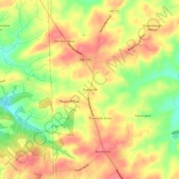
Name: Shawsville topographic map, elevation, terrain.
Location: Shawsville, Harford County, Maryland, 21161, United States (39.61788 -76.57497 39.65788 -76.53497)
Average elevation: 630 ft
Minimum elevation: 482 ft
Maximum elevation: 728 ft
Harford County trails, hiking, mountain biking, running and outdoor activities
Make a donation
Gear up for your next adventure:
As an Amazon Associate, this site earns from qualifying purchases at no extra cost to you.
Other topographic maps
Click on a map to view its topography, its elevation and its terrain.
Darlington
United States > Maryland > Harford County > Darlington > Hopkins Corner
Average elevation: 289 ft
Aberdeen Proving Ground
United States > Maryland > Harford County > Aberdeen Proving Ground
Average elevation: 23 ft
Make a donation
Gear up for your next adventure:
As an Amazon Associate, this site earns from qualifying purchases at no extra cost to you.
Make a donation
Gear up for your next adventure:
As an Amazon Associate, this site earns from qualifying purchases at no extra cost to you.