Geolocate
👉 Easily get elevation data in JSON, GeoTIFF and KML formats using Elevation API
Thank you for supporting this site ❤️
Make a donation

Diphu topographic map

Click on the map to display elevation.

About this map

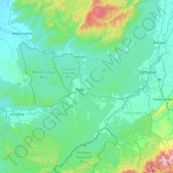
Name: Diphu topographic map, elevation, terrain.

Location: Diphu, Karbi Anglong, Assam, India (25.53113 93.13141 26.18047 93.83386)

Average elevation: 974 ft

Minimum elevation: 276 ft

Maximum elevation: 5,705 ft

Other topographic maps

Click on a map to view its topography, its elevation and its terrain.

Jorabat

India > Assam > Sonapur

Average elevation: 499 ft

Subansiri

India > Assam > Gogamukh

Average elevation: 315 ft

Diphu

India > Assam > Diphu

Diphu is located at 25°50′N 93°26′E / 25.83°N 93.43°E / 25.83; 93.43. It has an average elevation of 186 metres (610 feet). It is about 270 km by road and 213 km by railways from Guwahati. The town is located on a beautiful hill.

Average elevation: 630 ft

Tezpur

India > Assam > Tezpur

Average elevation: 223 ft

Kāmrūp

India > Assam

Average elevation: 1,083 ft

Badarpur

India > Assam > Badarpur > Badarpur

Average elevation: 89 ft

Numaligarh

India > Assam > Bokakhat > Numaligarh

Average elevation: 285 ft

Gear up for your next adventure:

🌡️Handheld Weather Meters - Measure wind, temp, and pressure for safe mountain travel
🛏️Cold Weather Sleeping Bag - Warm sleeping bag for cold conditions
🎒Day Hiking Backpack - Lightweight backpack perfect for day trips and outdoor adventures
🥾Men's Hiking Boots - Durable, waterproof footwear for rugged terrain and steep inclines
☀️Outdoor Sunscreen - High protection sunscreen for outdoor activities

As an Amazon Associate, this site earns from qualifying purchases at no extra cost to you.