
Make a donation
Gear up for your next adventure:
As an Amazon Associate, this site earns from qualifying purchases at no extra cost to you.
Cramahe topographic map
Click on the map to display elevation.
Make a donation
Gear up for your next adventure:
As an Amazon Associate, this site earns from qualifying purchases at no extra cost to you.
About this map
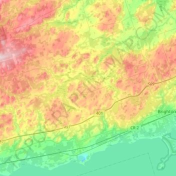
Name: Cramahe topographic map, elevation, terrain.
Average elevation: 535 ft
Minimum elevation: 154 ft
Maximum elevation: 1,083 ft
Make a donation
Gear up for your next adventure:
As an Amazon Associate, this site earns from qualifying purchases at no extra cost to you.
Other topographic maps
Click on a map to view its topography, its elevation and its terrain.
Grafton
Canada > Ontario > Northumberland County > Alnwick/Haldimand > Grafton
Average elevation: 407 ft
Presqu'ile Provincial Park
Canada > Ontario > Northumberland County > Brighton
Average elevation: 249 ft
Make a donation
Gear up for your next adventure:
As an Amazon Associate, this site earns from qualifying purchases at no extra cost to you.
Campbellford
Canada > Ontario > Northumberland County > Trent Hills > Campbellford
Average elevation: 571 ft
Warkworth
Canada > Ontario > Northumberland County > Trent Hills > Warkworth
Average elevation: 541 ft
Camborne
Canada > Ontario > Northumberland County > Hamilton Township > Camborne
Average elevation: 643 ft
Make a donation
Gear up for your next adventure:
As an Amazon Associate, this site earns from qualifying purchases at no extra cost to you.